
Archive
Western Star Resources Completes Phase 1 Exploration at Rowland Tungsten Property and Confirms Three Zones of Extensive Historical Tungsten Workings
 | |||||||||
Vancouver, British Columbia - 28th May, 2026 - TheNewswire - Western Star Resources Inc. (CSE: WSR) (OTC: WSRIF) (the “Company” or “Western Star”) is pleased to announce the successful completion of Phase 1 exploration at its 100% owned, past-producing Rowland Tungsten Property in Elko County, Nevada, USA.
The Phase 1 program comprised a high-resolution UAV magnetic geophysical survey, focused soil geochemistry, rock-chip sampling, and field checking of historical workings. Samples have been submitted to the laboratory and rush processing requested in order to return assay results as quickly as possible.
The Phase 1 field program has materially increased the Company’s understanding of the property. Four discrete zones of extensive historical tungsten-bearing workings have been confirmed on the ground, all hosted within the same skarn-style geological setting as the originally targeted Rowland workings.
Key Highlights:
-
Phase 1 exploration successfully completed at the Rowland Tungsten Property, comprising a property-wide UAV magnetic survey, focused soil geochemistry, rock-chip sampling, and LiDAR target ground-truthing.
-
Four discrete zones of extensive historical tungsten-bearing workings confirmed on the ground; Northern Zone A and B, Central Zone, and the original Rowland Zone.
-
Northern Zone B: the most significant historical development identified on the property. Field crews confirmed dilapidated wooden infrastructure consistent with a historical ore chute and several decommissioned shafts.
-
Rowland Main: multiple additional workings, trenches, and surface disturbances confirmed on the ground, with extensive UV fluorescence consistent with significant scheelite mineralization.
-
The UAV magnetic survey has been completed and is currently being processed, with preliminary results expected imminently.
-
Soil sampling completed across the Rowland Main zone, with reconnaissance soil lines extended across the Northern zones (A and B).
-
Rock samples and the initial round of soil samples have been rush-submitted to the laboratory; assay results are expected over the coming weeks.
Blake Morgan, the CEO and President of Western Star, stated “Rowland has come out of Phase 1 looking considerably more prospective than the historical record suggested. We expected a single past-producing zone; the field crew came back with multiple zones of extensive historical development, including a previously undocumented central area with processing infrastructure, shafts, and 600 to 700 metres of trenching. We adjusted the program in real time to focus on what was actually on the ground, and have rush-submitted the first round of rock and soil samples so we can get assays back as quickly as possible. The team can now move on to the White Star property where we hope to repeat the success we have had at Rowland.”
Phase 1 Field Program Summary
The Phase 1 field program at the Rowland Tungsten Property was designed to deliver an integrated package of geophysical, geochemical, and field-mapping data to support drill targeting and the drill-permitting process.
This phase has confirmed multiple zones of extensive historical tungsten-bearing workings across the property. All zones are hosted within the same contact metamorphic tungsten skarn setting as the originally targeted Rowland workings, and all display significantly more historical development than was recorded in publicly available historical records.
Northern Zones
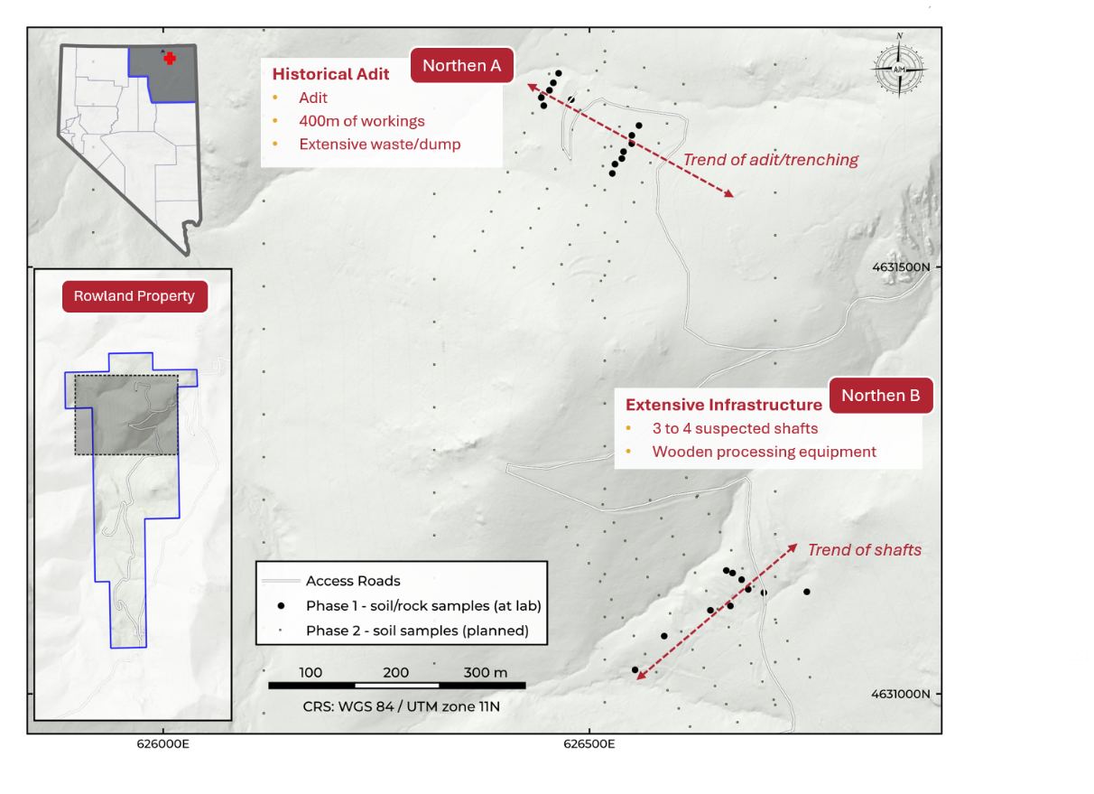
The Northern Zone A is the area that prompted the Company’s prior expansion of the Rowland claim package, and the Phase 1 field results validate that decision. Desktop work identified the area as historically mapped as a single adit. Field crews confirmed the location of the adit, which is old and partially backfilled/demobilized. However, the surrounding waste dumps and surface piles are substantially larger and more extensive than the historical record indicates, indicating that a meaningful volume of historical material was mined and processed from this area.
Click Image To View Full Size
Figure 1: Map showing the locations of the two zones of historical workings in the Northern Area.
The Northern Zone B is the most significant historical development confirmed during Phase 1 and was not documented in publicly available historical production records. The zone was first identified as a target during the Company’s pre-mobilization LiDAR review, which flagged surface features consistent with historical workings including several overgrown depressions which were suspected of being decommissioned vertical shafts. Field work has now confirmed the suspected shafts, with 3 to 4 observed in the field.
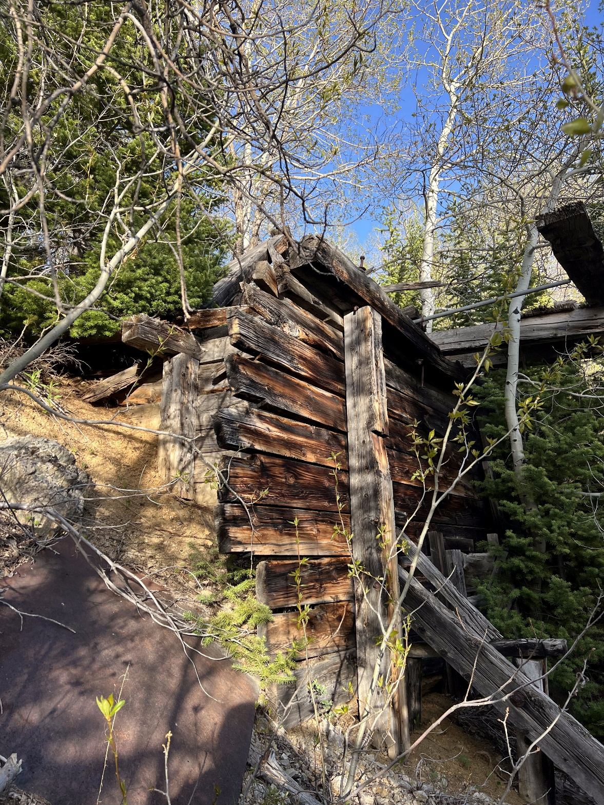
Field crews also documented dilapidated wooden infrastructure consistent with a historical ore chute (Figure 2), indicating that this area was a historical processing site for the broader Rowland operation. In addition, a series of northeast-southwest oriented trenches has been confirmed across the zone, testing approximately 600 to 700 metres of strike length.
Click Image To View Full Size
Figure 2: Wooden foundation of a suspect ore chute indicating this area is possibly the historical Rowland processing facility. Suspect shafts are located upslope of this structure
Rowland Main Zone
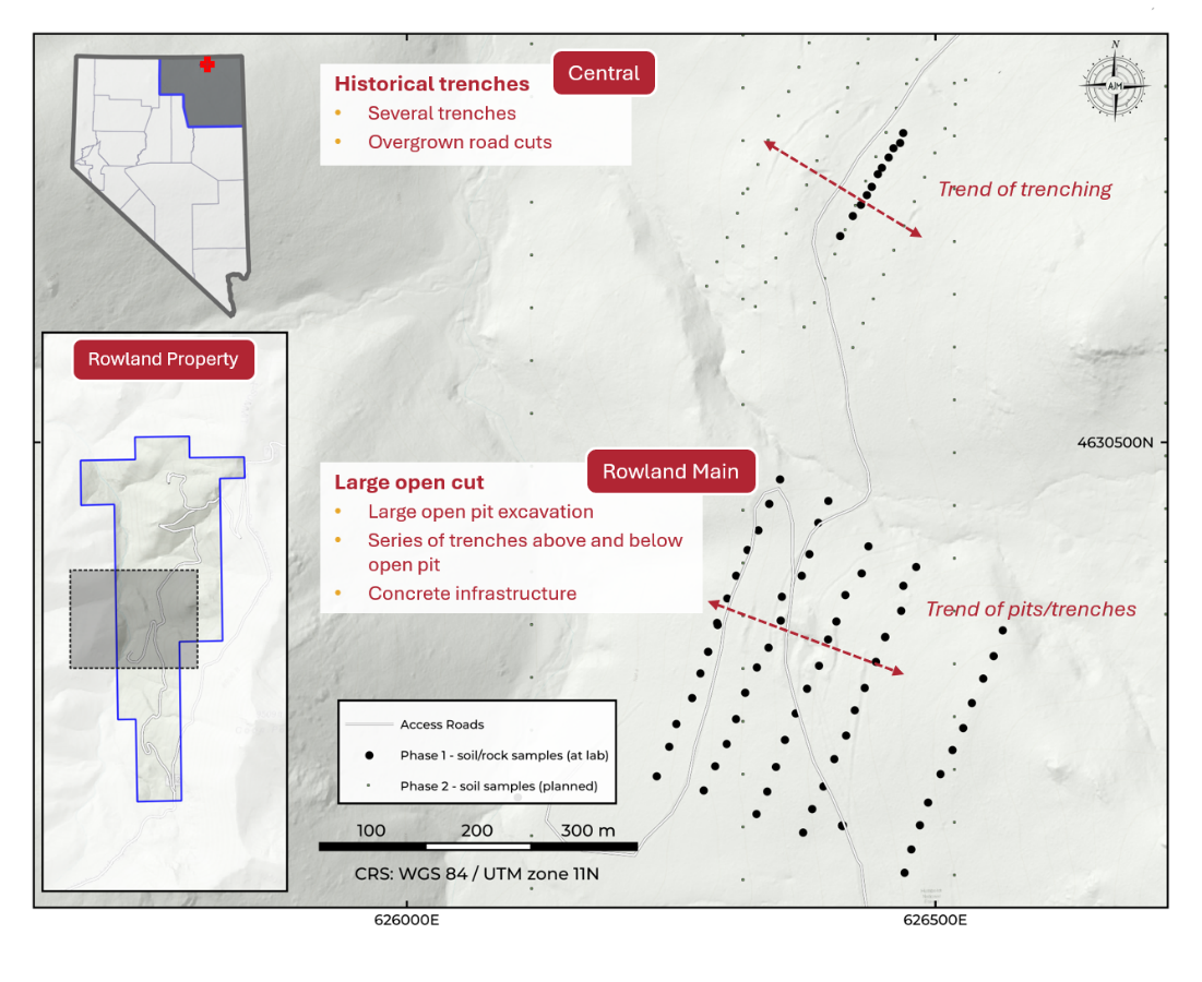
The Rowland Zone is the original target area on the property and the historical production area for which the Rowland property was acquired. Phase 1 field work confirmed multiple additional workings, trenches, and surface disturbances up and down the slope around the previously known features, materially increasing the inventory of confirmed historical workings within area.
Click Image To View Full Size
Figure 3: Central Zone and Rowland Main zone showing the phase 1 soil lines/grid and extent of historical workings.
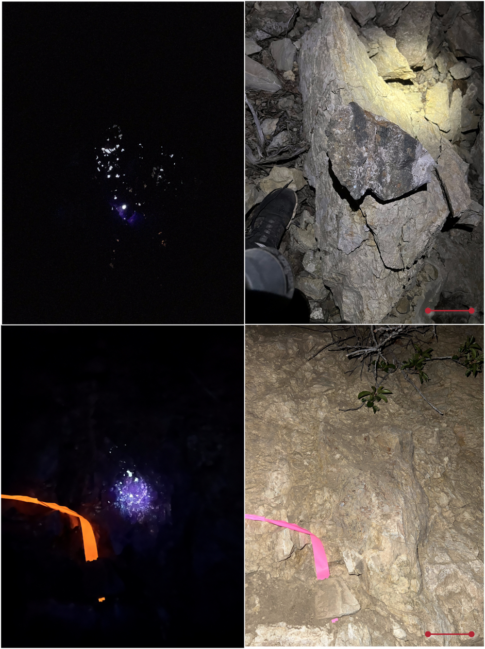
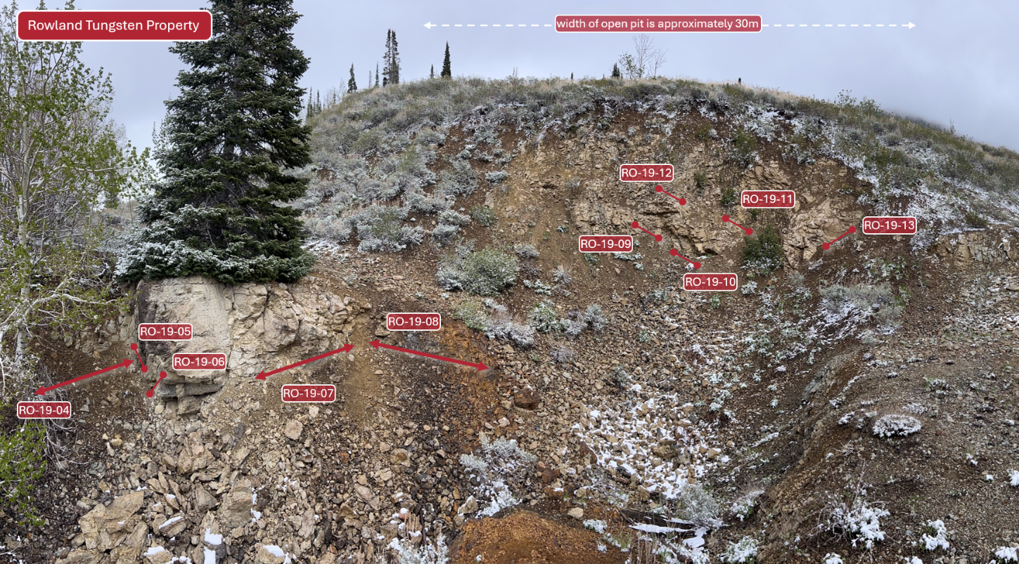
Material from the Rowland Zone displayed extensive UV fluorescence consistent with scheelite mineralization, with tungsten content further confirmed by portable XRF (pXRF) screening. Figure 4 shows the typical response when UV light is directed at outcrop and waste dumps. Strong fluorescent response is observed throughout most material, consistent with extensive scheelite mineralization. In order to characterise the distribution and grade across the open cut, a series of channel samples were taken across the various lithologies and contacts. Figure 5 shows the locations of these samples.
Click Image To View Full Size
Figure 4: examples from the Rowland open cut showing extensive scheelite fluorescence in both outcrop (bottom image) and float/waste (top image). Left image is under UV light, right image is under normal light.
Click Image To View Full Size
Figure 5: Panoramic image from the Rowland Open Cut showing locations of 1m and 30cm channel samples
UAV Magnetic Survey
The Phase 1 UAV magnetic survey at the Rowland Tungsten Property represents the first modern high-resolution geophysical dataset acquired across the property.
The data are currently being reviewed, processed, and interpreted, with delivery of preliminary results expected shortly.
Rush Assays, Phase 2, and Drill Targeting
With Phase 1 field work complete, the Company’s near-term priorities are to receive and integrate the Phase 1 assay results, finalize the Phase 2 program, and advance the project toward drill targeting and drill permitting. Rock samples and the initial round of Phase 1 soil samples have been rush-submitted to the laboratory, and the Company expects to receive the first tranche of assay results over the coming weeks.
The Company will provide further updates as Phase 1 assay results, geophysical interpretation products, and the Phase 2 program plan become available.
Qualified Person
The scientific and technical information contained in this news release has been reviewed and approved by Jasper Mowatt, MIMMM (Membership No. 0486653) and MAusIMM (Membership No. 3178851), a Qualified Person as defined by National Instrument 43-101 – Standards of Disclosure for Mineral Projects.
About Western Star Resources
Western Star Resources is a mineral exploration and development company. The Company’s objective is to increase shareholder value through the development of exploration properties using cost-effective exploration practices, acquiring further exploration properties and seeking partnerships by either joint venture or sale with industry leaders. The Company currently owns nine non-surveyed contiguous mineral claims totaling 4,740 hectares, which are located within the Revelstoke mining division of British Columbia. The Western Star property group is located approximately 50 kilometers southeast of Revelstoke, B.C., and roughly 10 kilometers north of the abandoned community of Camborne.
Contact Information:
Blake Morgan,
CEO and Director
blake@acvc.vc
Neither the Canadian Securities Exchange nor its Regulation Services Provider (as that term is defined in the policies of the Canadian Securities Exchange) accepts responsibility for the adequacy or accuracy of this press release.
Certain of the statements made and information contained herein may constitute “forward-looking information”. In particular references to the private placement and future work programs or expectations on the quality or results of such work programs are subject to risks associated with operations on the property, exploration activity generally, equipment limitations and availability, as well as other risks that we may not be currently aware of. Accordingly, readers are advised not to place undue reliance on forward-looking information. Except as required under applicable securities legislation, the Company undertakes no obligation to publicly update or revise forward-looking information, whether as a result of new information, future events or otherwise.