
Archive
Red Canyon Provides Exploration Update at its 100% Owned Osiris Copper-Gold Project
 | |||||||||
 |  |  | |||||||
Red Canyon Provides Exploration Update at its 100% Owned Osiris Copper-Gold Project
Vancouver, British Columbia, – TheNewswire - July 30, 2026: Red Canyon Resources Ltd. (“Red Canyon” or the “Company”) (CSE: REDC | OTCQB: REDRF | Frankfurt: I91) is pleased to announce the completion of the initial phase of its planned 2,500 metre diamond drill program at its 100% owned1 Osiris copper–gold project in central British Columbia, originally announced on June 8, 2026. Follow-up plans include testing additional, recently upgraded drill targets.
Company Highlights:
-
The Company has completed eight drill holes totalling 2,079 m at the Camp target within the Osiris Project. Based on this initial drilling, the Company interprets the Camp target to host an alkalic copper-gold mineral system with geological similarities to the Mount Polley and Mount Milligan mines in British Columbia.
-
An induced polarization (IP) geophysical survey was completed over a series of target areas at Osiris, resulting in the identification of several new high-priority targets. One of the highest-priority targets is at Nautilus, a 3.5 × 3.5 km complex magnetic feature associated with zones of high resistivity and moderate to high chargeability. Additional surface geochemical surveys are planned at Nautilus, with drilling potentially commencing in late summer.
-
The EV target comprises two large-scale, linear electromagnetic (EM) features. The Company plans to drill test the higher-amplitude feature to determine whether it represents a massive sulphide body.
-
A first-pass rotary/auger drilling program is planned to commence in mid-August and is designed to provide more definitive geochemical data in selected areas associated with priority targets.
Wendell Zerb, the Chairman and CEO of the Company, commented: “Red Canyon's initial drilling at the Camp Main Zone has intersected hydrothermally altered, copper-mineralized porphyritic rocks. Based on the host geology, alteration style, and mineralization observed at Camp, the Company believes the area hosts an alkalic copper-gold system with geological similarities to other alkalic copper-gold systems in British Columbia and worldwide.
Supported by the recently completed IP survey, the Camp mineral system remains open for expansion along its 2.75 km magnetic trend. In addition, several new high-priority target areas, which have never been drill tested, have been identified through recent geophysical surveys and are being prepared for drilling.”
Red Canyon Projects
The Company holds a portfolio of seven 100%-owned1 projects in British Columbia and Nevada. High priority projects are Kendal in west-central British Columbia, Inzana (Osiris and Acheron) in central British Columbia and Scraper Springs in northeast Nevada.
Osiris Project
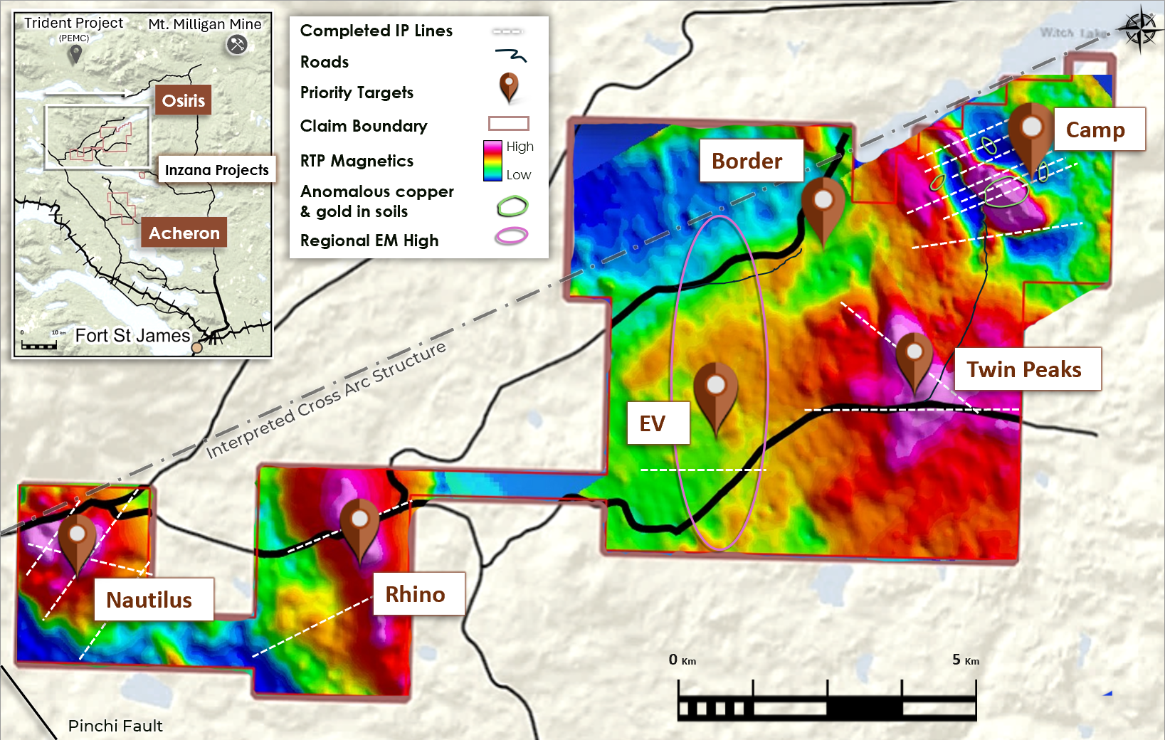
The Osiris Project forms the northern part of the Inzana project area. The Inzana project area is in central British Columbia, approximately 60 km northwest of the district municipality of Fort St. James and 35 km west-southwest of Centerra Gold’s Mount Milligan copper-gold mine (Figure 1). The area has excellent access, provided by primary and secondary forestry roads.
Scott Geophysics completed 38 line-kilometres of dipole-dipole induced polarization (IP) surveys across multiple target areas (Figure 1) and provided inversion models of each survey line, which were reviewed and further interpreted by Fathom Geophysics. The IP survey lines were designed to complement existing target models and geological interpretations. Several areas of interest have IP responses characteristic of known porphyry models. Mineralization at the Camp Main Zone is associated with high resistivity and moderate to high chargeability. Target areas upgraded in the current program, based on new IP results, include Camp, Nautilus and EV. Twin Peaks IP signatures are affected by a conductive horizon that is interpreted to limit IP signal penetration. Rhino IP results were limited to two lines which did not identify favorable anomalies. Both areas remain of interest but are downgraded in terms of priority while awaiting additional information.
Click Image To View Full Size
Figure 1: Osiris Project, targets for 2026 fieldwork, completed IP lines and the Camp target location.
Camp Copper-Gold Porphyry Target
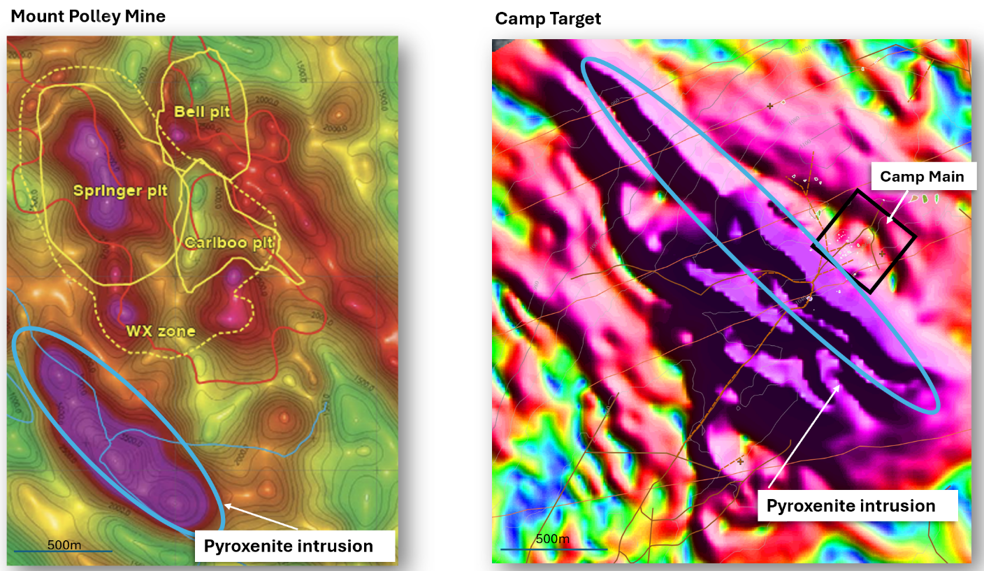
The Camp target is associated with a 2.75 by 2.25 km NNW-trending high magnetic feature with a strong central induced core surrounded by a large remanent magnetic halo (Figures 2 and 3). Recent drilling indicates the predominant magnetic high core is due to a NW-trending magnetite-rich pyroxenite intrusive complex. This pyroxenite body is interpreted to be an early phase of the alkalic system at Camp. The Mount Polley Mine (Imperial Metals Corporation) alkalic copper-gold system hosts a pyroxenite body adjacent to the main zones of mineralization (Figure 3). Additional magnetic features occur on the margins of the Camp pyroxenite body including the remanent magnetic highs associated with altered and mineralized hornblende and plagioclase porphyries.
Click Image To View Full Size
Figure 2: Mount Polley RMI magnetics with surface outline of open pit zones and relative locations of pyroxenite intrusion* (left). Camp target CHG magnetics with location of Camp Main Zone and relative location of pyroxenite intrusion (right). Both maps are at the same scale.
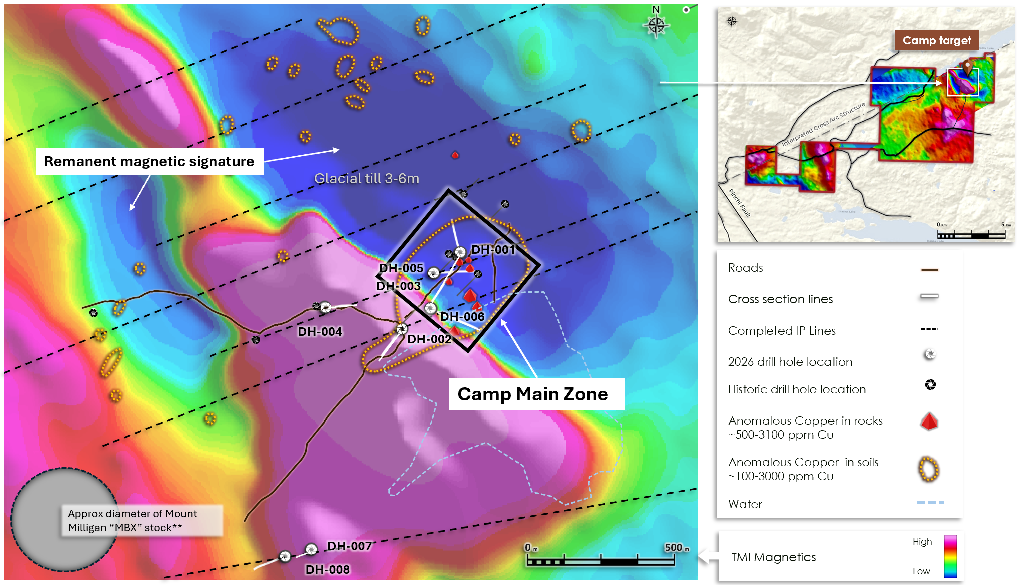
The Camp porphyry units are interpreted to be highly oxidized, variably hydrothermally altered, silica-undersaturated alkalic intrusions and dykes. Four drill holes tested the Camp Main Zone, an area covering approximately 300 by 300 m (Figures 2 and 3). These holes intersected structurally complex zones of variably altered and mineralized copper-gold alkalic porphyry and hornfelsed sedimentary and volcanic rock. Based on local and regional mapping, the Company interprets the mineral system at Camp to be tilted following porphyry emplacement and later structurally displaced along NW and ENE fault zones. The Company geologists observed notable changes in alteration and mineralization across fault boundaries. The Mount Milligan Mine 35 km to the east hosts a series of mineralized alkalic intrusions which have been tilted to the east and subsequently faulted along NW structures.
Click Image To View Full Size
Figure 3: The Camp target highlighted by airborne TMI magnetics, rock and soil geochemistry, drill hole locations and for scale the approximate comparative size footprint of the Mount Milligan Mine MBX Stock**.
Drilling at the Camp Main Zone intersected classic alteration assemblages characteristic of alkalic copper-gold systems. Assays for the initial drilling program are expected within 4 to 6 weeks.
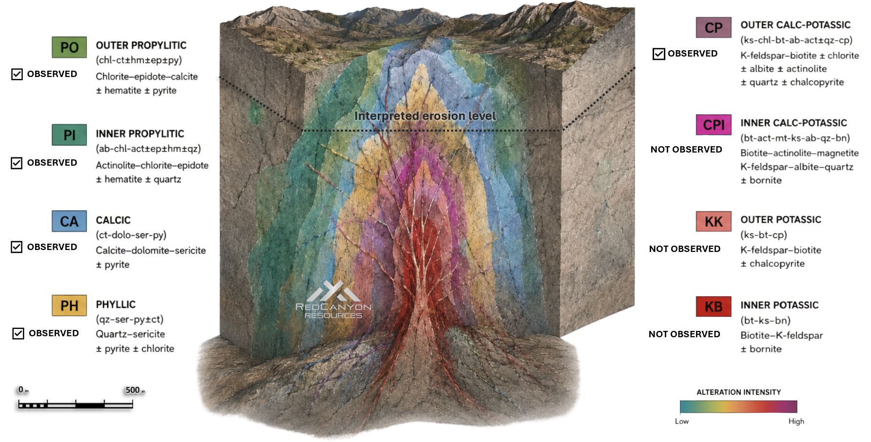
Alteration mineral assemblages observed in drill core at Camp include chlorite-calcite±hematite±epidote±pyrite interpreted as propylitic (PO), albite-chlorite-actinolite-epidote±hematite±quartz interpreted as inner propylitic (PI), calcite-dolomite-sericite-pyrite interpreted as calcic (CA), quartz-sericite-pyrite±calcite interpreted as phyllic (PH), potassium feldspar-chlorite-biotite-albite-actinolite±quartz±chalcopyrite interpreted as outer calc-potassic (CP) (Figures 4 and 5).
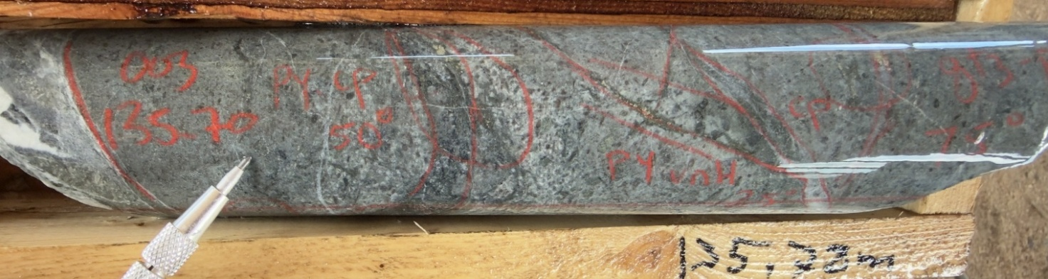
Sulphide zones observed in drill core include pyrite only with PO and PH alteration, pyrite> chalcopyrite with CP, PH and PI alteration, and chalcopyrite>pyrite with CP alteration. Copper mineralization occurs in micro veinlets and as disseminations most commonly associated with outer CP alteration.
Click Image To View Full Size
Figure 4: RCOS-26-003 altered hornblende porphyry with pyrite and chalcopyrite in veinlets and fractures
Hydrothermal breccias have also been observed, but thus far are limited at Camp Main Zone. A 4m breccia observed in drill hole RCOS-26-06 contained several clasts with an estimated 5 to 7% chalcopyrite, indicating that the system potentially hosts high grade zones and clasts of this material were cut and transported within the breccia.
Drilling did not intersect biotite or potassium feldspar-dominant potassic alteration, which is potentially associated with bornite/chalcopyrite mineralization within the core of alkalic porphyry copper system.
Click Image To View Full Size
Figure 5: Alkalic copper-gold model with alteration suite ranging from outer propylitic to inner potassic. Figure includes alteration observed at Camp Main Zone in current drill program.
The Camp Main Zone mineralization is associated with moderate to high-resistivity and moderate-chargeability IP responses. Expanded IP coverage at Camp has outlined a 2.0 km-long, north-northwest (NNW) trend to this resistive feature that occurs east of the pyroxenite intrusion and parallel to a northwest (NW) trending, east-dipping fault.
Several similar, subparallel zones of moderate to high resistivity and moderate chargeability occur east of the Camp Main Zone and also extend for approximately 2.0 km to the north.
Two drill holes tested the main NW-trending prominent magnetic feature at Camp. Drill holes RCOS-26-02 and RCOS-26-04 tested a corresponding high resistivity and moderate chargeability high. Both holes intersected magnetite-rich pyroxenite (Figure 3), interpreted to be an early phase of the alkalic system. This unit is intruded by later phases of altered hornblende porphyry dykes and is parallel and west of a NW-trending, east-dipping structure that is possibly a long-lived fluid pathway, which potentially effected the emplacement of the porphyry system at Camp.
Drill holes RCOS-26-007 (DH-07) and RCOS-26-008 (DH-08) tested a resistivity high, a coincident magnetic high, and a remanent magnetic trend on the interpreted southwest extension of the Camp system (Figure 2) located approximately 1.2 km from the Camp Main Zone. Drill hole 07 intersected an altered diorite intrusion tracking a clear, down-hole prograde hydrothermal sequence. Upper zones show patchy to pervasive chlorite-calcite alteration, grading into patchy actinolite and potassium feldspar at depth.
Drill hole DH-08 tested the edge of the magnetic high and its transition to a remanent magnetic high that corresponds with an IP resistivity high and increasing chargeability high to the west. A similar remanent magnetic feature associated with the Camp Main Zone occurs on the west side of the pyroxenite and remains largely untested by drilling. Drill hole 08 intersected the same altered diorite intrusion and prograde hydrothermal sequence observed in DH-07, while successfully stepping out further into the system. Advancing deeper, DH-08 cut a significant series of hornfelsed sediments, quartz-sericite altered porphyries, and an intense epidote-potassium feldspar-biotite hydrothermal breccia. This series of propylitic, phyllic, and calc-potassic altered porphyritic rocks and hornfels sediments are interpreted to be an extension of the Camp porphyry system extending the trend of altered porphyritic rocks 1 km to the southwest and the system to over 2.7 km from north to south.
The Company interprets the Camp hydrothermal system to be open along the trend of the main magnetic high and the remanent magnetic high, which extends in a north-northwest direction. Outside of the Camp Main Zone, much of the Camp area is covered by various thicknesses of glacial till. The Company believes this glacial till masks geochemical responses in historical soil surveys completed over the Camp area, which have outlined discontinuous zones of anomalous copper, molybdenum, and gold associated with this NW-trending resistivity and chargeability trend (Figure 2).
Osiris Priority Targets
Red Canyon has conducted a project-wide airborne magnetic and radiometric survey, completed by Precision Geosurveys, with Fathom Geophysics completing data filtering and MVI modelling. Scott Geophysics completed IP surveys on select target areas outlined in Figure 2. Much of the area is glacial till covered and select soil and till sampling programs have been completed over the area and in association with specific targets. The Company is currently expanding soil/till geochemistry surveys.
A program of up to 40 rotary/auger drill holes is planned to commence in early to mid-August. Road accessible areas identified by Red Canyon will be tested with the goal of collecting a basal till sample and cuttings/rock chips of the bedrock. This rotary/auger drill program is designed to provide more conclusive geochemical sample data in select areas associated with geological and geophysical targets.
Nautilus
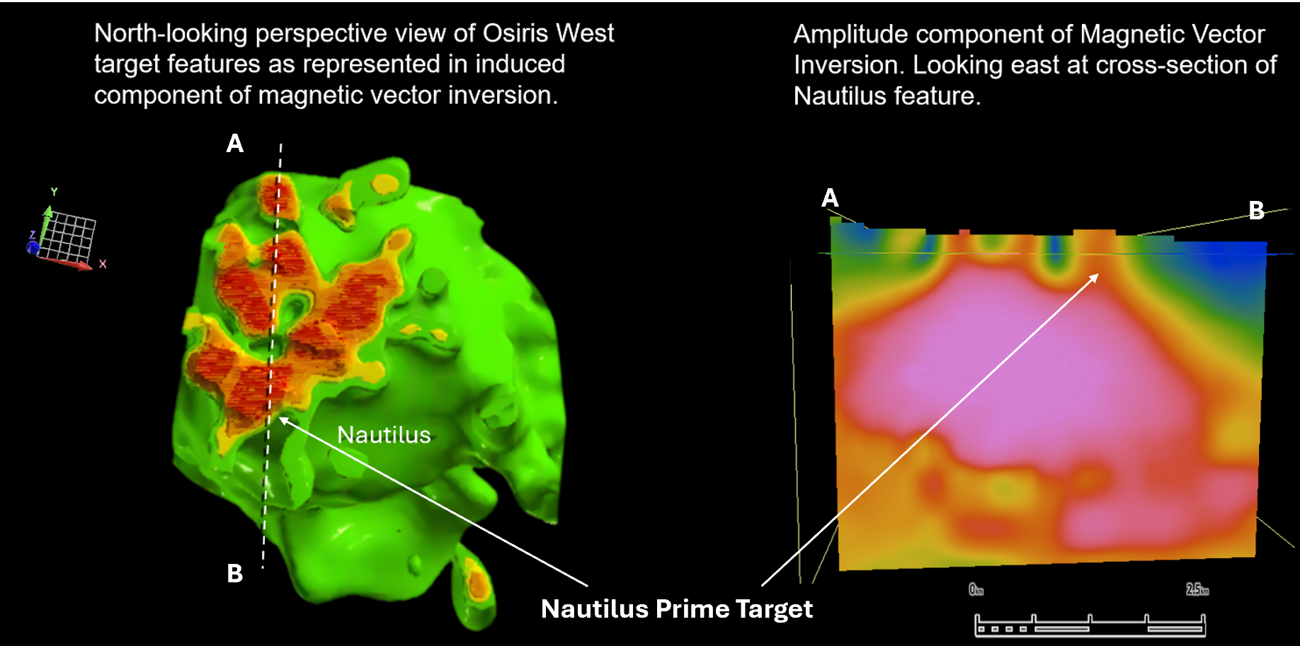
The Nautilus target is characterized by a complex circular magnetic feature measuring approximately 3.5 by 3.5 km. The target is bounded to the west by the Pinchi Fault and to the north by an interpreted west-southwest-trending cross-arc structure (Figure 1). MVI modelling identified multiple magnetic pipe-like features interpreted as possible porphyry intrusions emanating from a larger magnetic body at depth, which may represent a potential causative porphyry intrusion (Figures 6 and 7).
Click Image To View Full Size
Figure 6: Magnetic Vector Inversion model of Nautilus target areas.
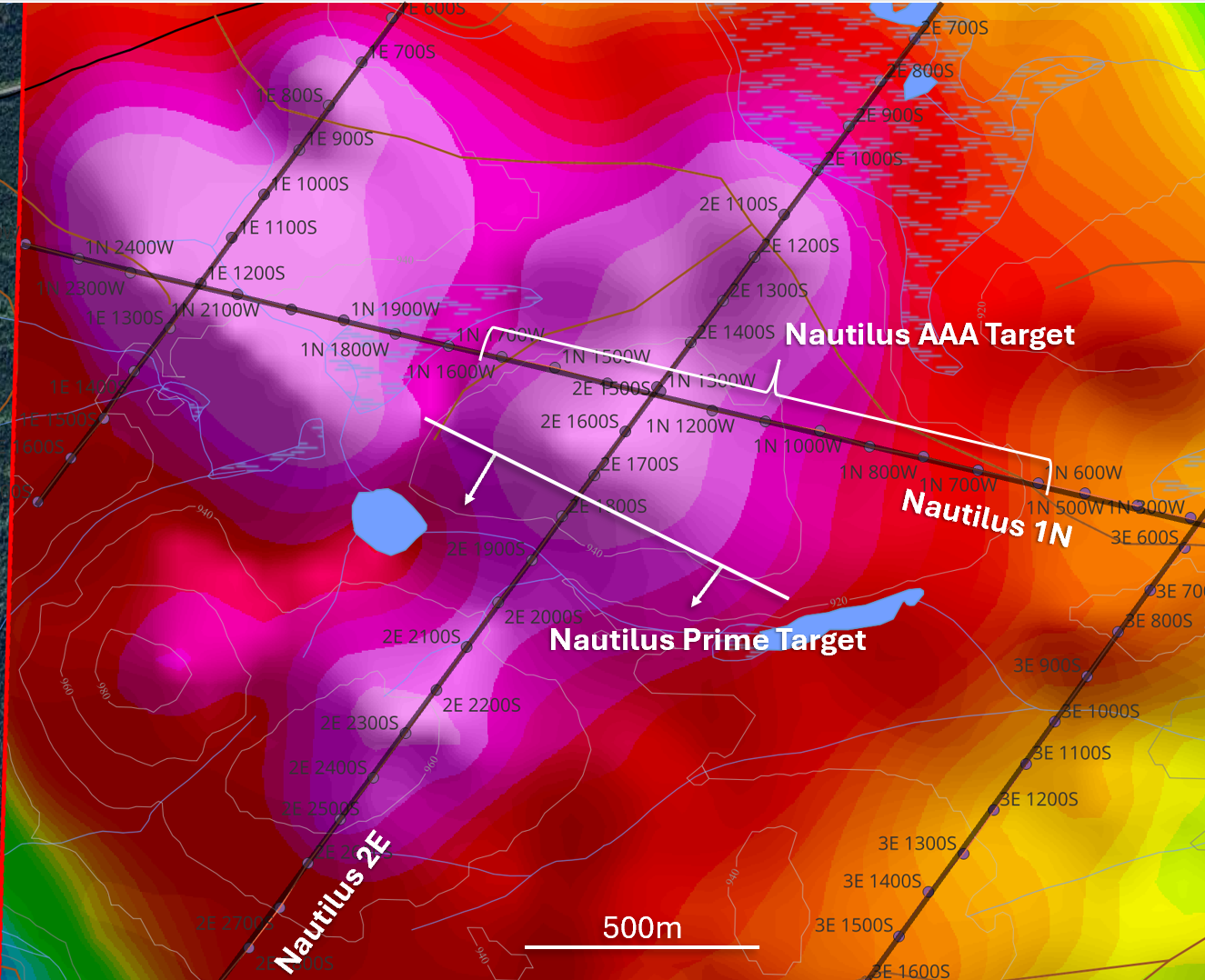
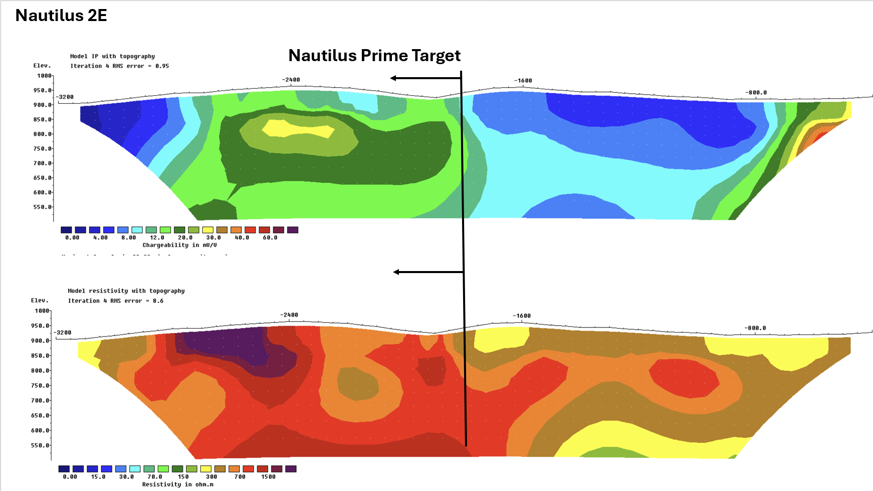
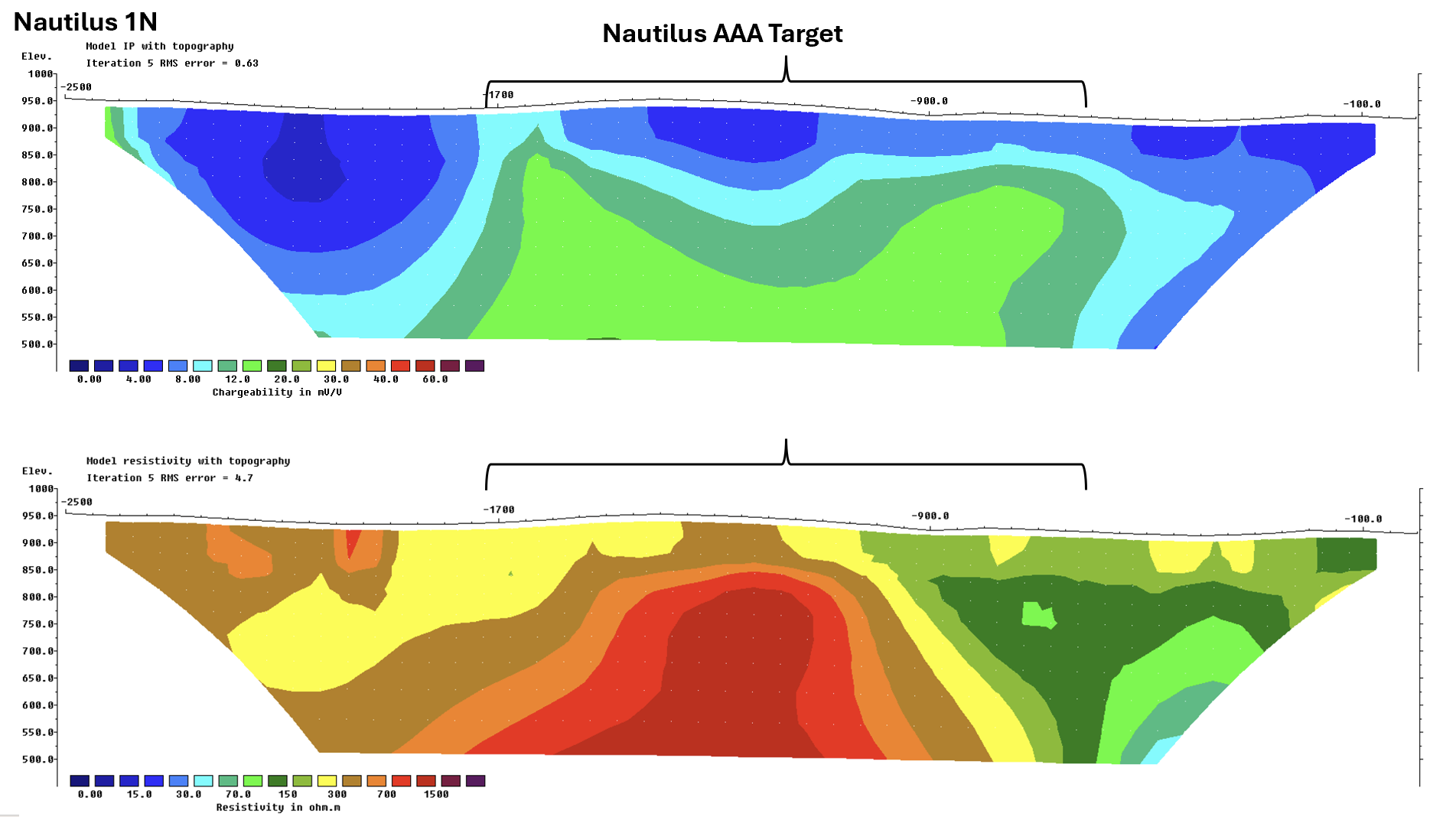
Four IP survey lines were completed over the Nautilus target (Figure 7). Lines 1N and 2E (Figures 7, 8, and 9) identified two new high-priority target areas based on coincident magnetic highs and corresponding zones of high resistivity with moderate to high chargeability. The Company interprets these geophysical signatures as potentially representing altered and mineralized porphyry intrusions.
Active logging operations in the area currently limit access to parts of Nautilus. However, the Company expects that newly constructed forestry roads and cut blocks will significantly improve access to the Nautilus Prime and AAA target areas, enabling completion of a new soil and till geochemistry program. Access for drill rigs is anticipated by late August.
Click Image To View Full Size
Figure 7: Plan view RTP magnetics with IP lines and target areas at Nautilus.
Click Image To View Full Size
Figure 8: IP Inversion section Line 2E at Nautilus. upper section Chargeability, lower section is Resistivity.
Click Image To View Full Size
Figure 9: IP Inversion section Line 1N at Nautilus. upper section Chargeability, lower section is Resistivity.
EV
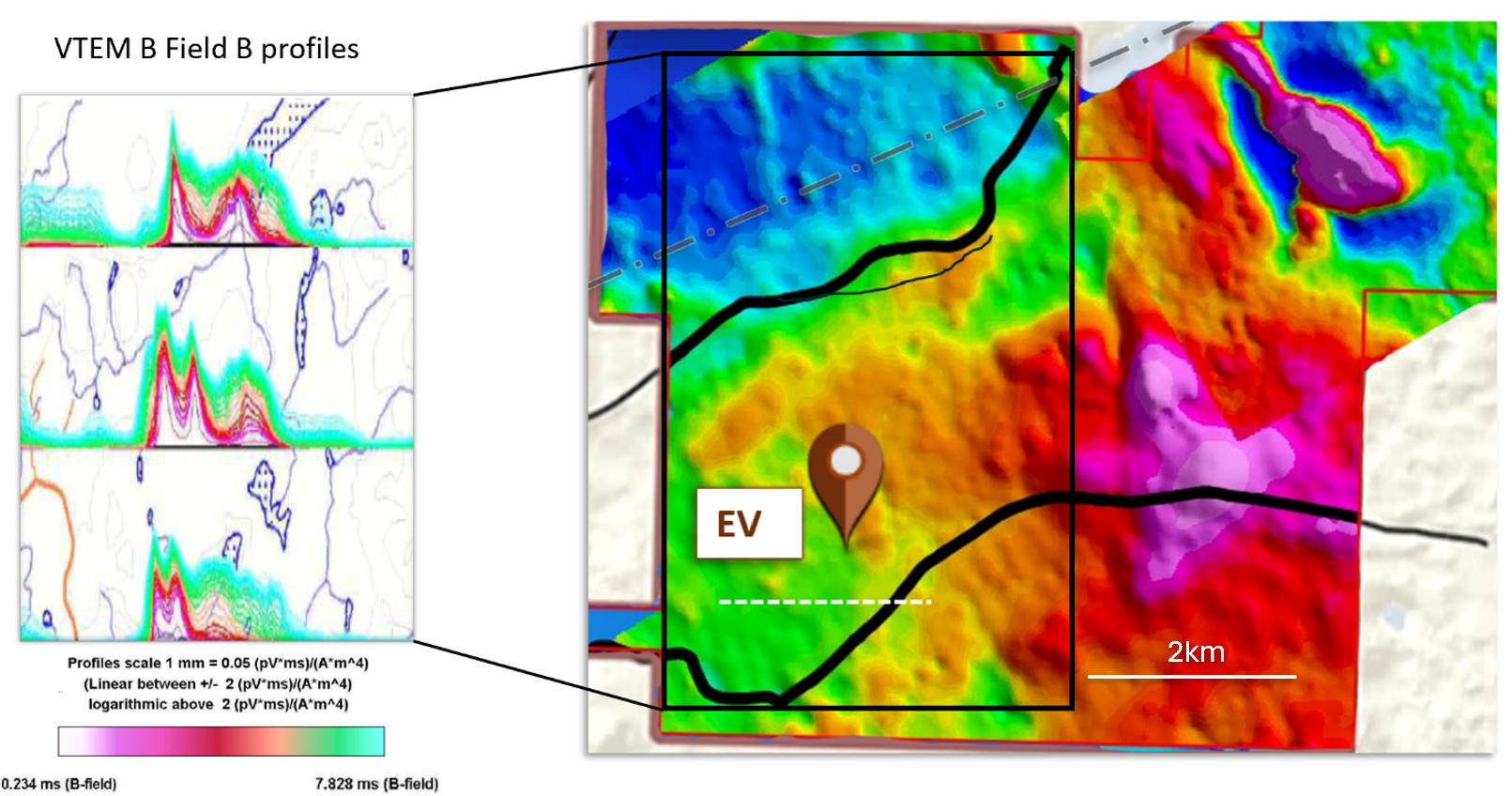
The EV target represents two large-scale, linear electromagnetic (EM) features. The higher-amplitude EM feature is one of the highest amplitude conductors measured by regional surveys in this part of British Columbia (Figure 10). The Company completed one line of IP geophysics across the main EM feature to confirm the features conductivity and location. Fathom Geophysics interprets the main EM anomaly to be a steep, east-dipping tabular body within 25 m of surface and approximately 20 m in width. The high amplitude of the EM signature suggests this feature could represent massive sulphides or potentially highly graphitic sediments. Given the close association of the EV location with the margins of a complex island arc setting, the Company believes the EV target could represent a volcanogenic massive sulphide body. The trend of the EM conductor has a weak magnetic signature and till cover in the area limits geochemistry as an effective exploration tool. The Company plans to drill test this target to intersect the highest conductivity and determine the source of the feature.
Click Image To View Full Size
Figure 10: Cross section of VTEM conductor profiles of regional Quest survey data - EV target.
About Red Canyon Resources
Red Canyon Resources Ltd. (CSE: REDC) is a technically driven, discovery-focused mineral exploration company exploring North America’s top copper jurisdictions. The Company’s core goal is to make impactful copper discoveries and has a portfolio of 100% owned copper and copper-gold porphyry exploration projects.
The Company’s technical team consists of experienced geoscientists with diverse capital market, junior, and major mining company backgrounds and a track record of success.
For more information, please visit the Company's website at www.redcanyonresources.com.
Red Canyon is part of the NewQuest Capital group which is a discovery-driven investment company that builds value through the incubation and financing of mineral projects and companies. Further information about NewQuest can be found on the company website at www.nqcapitalgroup.com.
1 Red Canyon has two projects subject to option earn in agreements whereby the Company can earn into 100% of the project.
* Source: Geoscience BC – Porphyry districts of British Columbia Atlas Series
** Source: Centerra 2020, Fitzgerald et al 2020
The Canadian Securities Exchange does not accept responsibility for the adequacy or accuracy of this news release.
Qualified Person:
The technical information contained in this update has been reviewed and approved by Wendell Zerb, P. Geol, a “Qualified Person” (“QP”) as defined in National Instrument 43-101 – Standards of Disclosure for Mineral Projects. Mr. Zerb is not independent by reason of being the Chairman, President and CEO of the Company. In presenting examples in this release for comparison including the Mount Polley Mine and the Mount Milligan Mine in British Columbia, the Company in no way implies that future exploration will necessarily result in the discovery of similar economic mineral deposits. *The Qualified Person has not verified the information on theses deposits and the information disclosed is not necessarily indicative of mineralization on Red Canyon projects.
FORWARD-LOOKING STATEMENTS
This news release includes certain forward-looking statements and forward-looking information (collectively, “forward-looking statements”) within the meaning of applicable Canadian securities legislation. All statements, other than statements of historical fact, included herein including, without limitation, statements regarding future capital expenditures, exploration activities and the specifications, targets, results, analyses, interpretations, benefits, costs and timing of them, and the anticipated business plans and timing of future activities of the Company, are forward-looking statements. Although the Company believes that such statements are reasonable, it can give no assurance that such expectations will prove to be correct. Often, but not always, forward looking information can be identified by words such as “pro forma”, “plans”, “expects”, “may”, “should”, “budget”, “scheduled”, “estimates”, “forecasts”, “intends”, “anticipates”, “believes”, “potential” or variations of such words including negative variations thereof, and phrases that refer to certain actions, events or results that may, could, would, might or will occur or be taken or achieved. Forward-looking statements involve known and unknown risks, uncertainties and other factors which may cause the actual results, performance or achievements of the Company to differ materially from any future results, performance or achievements expressed or implied by the forward-looking statements. Such risks and other factors include, among others, risks related to the anticipated business plans and timing of future activities of the Company, including the Company’s exploration plans and the proposed expenditures for exploration work thereon, the ability of the Company to obtain sufficient financing to fund its business activities and plans, the ability of the Company to obtain the required permits, changes in laws, regulations and policies affecting mining operations, the Company’s limited operating history, currency fluctuations, title disputes or claims, environmental issues and liabilities, as well as those factors discussed under the heading “Risk Factors” in the Company’s prospectus dated October 12, 2023 and other filings of the Company with the Canadian Securities Authorities, copies of which can be found under the Company’s profile on the SEDAR+ website at www.sedarplus.ca.
Readers are cautioned not to place undue reliance on forward-looking statements. The Company undertakes no obligation to update any of the forward-looking statements, except as otherwise required by law.