Archive
Exploits Discovery Identifies Three Defined Drill Targets at the True Grit Gold Project
 | |||||||||
Vancouver, British Columbia - TheNewswire - March 18th, 2021 - Exploits Discovery Corp. (“Exploits” or the “Company”) (CSE:NFLD) (OTC:RNRRF) (FSE:634-FF) (CNSX:NFLD) is pleased to announce that the Company, along with its exploration partner GoldSpot Discoveries Corp. (“Goldspot”) (TSX.V: SPOT), has defined three high priority drill targets through Goldspot’s proven artificial intelligence (A.I.) machine learning and data analysis technology, which was instrumental in New Found Gold’s discovery of the Keats and Lotto zones.
-
- The True Grit Project hosts the GRUB Line, a deep seated gold bearing fluid conduit that crosses the Exploits sub zone and defines mineral pathways similar to the Appleton Fault, the Joe Batts Pond Fault and the Dog Bay Line.
- In the last six months Exploits has undertaken:
-
- A high resolution (100m spacing) airborne VTEM geophysical survey.
- SGH soil grid analysis
- Surficial structural mapping and sampling
- Historic drill data compilation and modeling
-
Where we are going:
-
- Goldspot has identified three high priority exploration targets using proven techniques similar to those used by GoldSpot for New Found Gold’s Keats high grade epizonal gold discovery where they drilled 92.86 g/t Au over 19 metres.
- The geophysical targets display a structural patterns of primary and secondary faulting, that is reinforced by results of SGH soil anomalies, structural mapping, sampling, and 3D modeling of historic shallow drilling.
- The True Grit Property is road accessible and fully permitted for drilling in Spring of 2021. It is the first prospect in a series of five drill targets that Exploits is focused on drilling in the spring of 2021.
Michael Collins, president and chief executive officer of Exploits, commented: "Exploits exploitation strategy is benefiting our shareholders. In only 6 months we have defined and filed drill permits on 5 projects. With our first permit at True Grit we have defined 3 new targets. That is based on a synthesis of new and old geological information by some of the best minds and A.I. in the business. We look forward to drilling at True Grit and applying our exploration model to the next 4 projects.”
The companies have identified 3 high priority drilling targets on the True Grit Gold Property, (Figures 1 and 2). GoldSpot’s data analysis techniques along with Exploits’ historic data compilation, SGH soil survey, and preliminary results from the new high resolution airborne VTEM survey have clearly defined new gold targets for drill testing at True Grit.
True Grit Magnetic and SGH Soil Map
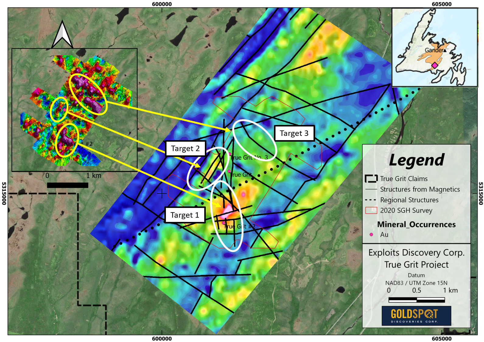
Click Image To View Full Size
Figure 1: Preliminary airborne magnetic data map from Exploits’ high resolution VTEM survey with GoldSpot’s structural analysis. The inset map displays the SGH soil results with anomalous gold responses shown to correlate with magnetic highs. The strongest SGH and mag high signatures occur in prominent north-south trending fault structures, resulting in the first high priority target (Target 1).
The True Grit Project is host to the deep seated GRUB Line fault zone, a known conduit for gold mineralization and gold bearing fluids across the Exploits subzone. The preliminary results have identified a structural pattern of primary and secondary fault structures associated with the GRUB Line, similar to structures Goldspot identified on New Found Gold’s Queensway South project.
Current evidence suggests that historical exploration drilling took place on the fringe of the identified targets and the gold intercepts discovered to date are potentially distal to the main mineralized bodies.
Target 1: 3D geological modeling of the historical drilling at True Grit indicates that veining may have a spatial/geometric association with metasediment rock units, coincident with north-south EM conductors. This target was poorly tested by shallow historic drilling that missed both the EM-sedimentary rock hosted anomaly as well as the SGH/Magnetic anomaly. This suite of features are usually expressed by rocks that have been broken up and subject to fluid flow. This structural preparation gives the host rock a higher capacity to host significant gold mineralization than the adjacent areas of known gold mineralization on the True Grit Project.
True Grit Magnetic and EM Map
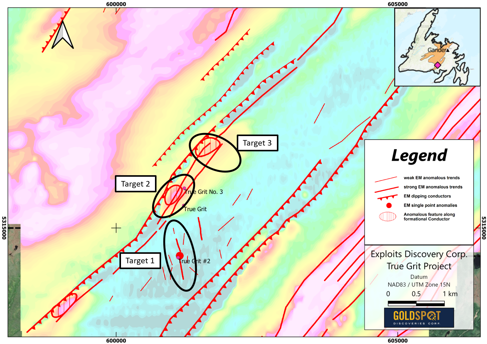
Click Image To View Full Size
Figure 2: Map of preliminary EM data over the True Grit project defining 3, northeast trending anomalous features along a formational conductor (red circles). North-south trending, anomalous EM lineaments (red lines) correlate with the magnetic structures delineated in Figure 1 (Target 1) which run into the central (Target 2) and northern (Target 3) formational conductors, culminating in two more additional high priority targets.
Untested Targets 2 and 3, were identified on a conductive northeast trending EM anomalies along a major fault structure.
Target 2: is a coincident magnetic high and conductive EM anomaly, overlaid by intersecting major north trending and northeast trending faults to the north of known low grade gold mineralization. It is the strongest of the three highlighted EM conductors and has the structural complexity to develop open spaces required for deposition of gold mineralization.
Target 3: is a coincident conductive EM signature and high priority SGH gold soil anomaly. The SGH gold soil anomaly is spatially associated with an interpreted northwest trending fault, defined by magnetic inversion data, and cross cuts the regional scale EM conductor. This interpreted structural network of primary and secondary structures is critical for the generation and emplacement of epizonal, orogenic gold mineralization.
The True Grit property is 100% owned by Exploits Discovery, subject to a 2% royalty with a 1% buy back for $1 million. It is easily accessible, located only two km west of the junction of the Harbour Breton (Route 360) and St. Alban's highways (Route 361) in the Baie d' Espoir area of Newfoundland's Exploits subzone.
*This press release contains information with respect to adjacent or similar mineral properties which the Company has no interest or rights to explore or mine. Readers are cautioned that the Company has no interest in or right to acquire any interest in any such properties on adjacent or similar properties are not indicative of mineral deposits on the Company’s properties.
National Instrument 43-101 disclosure
Ian Herbranson, P.Geo, is Vice-President of Exploration for the company and qualified person as defined by National Instrument 43-101. Mr. Herbranson supervised the preparation of the technical information in this news release.
About Exploits Discovery Corp.
Exploits Discovery is a Canadian mineral exploration company focused on the acquisition and development of mineral projects in Newfoundland, Canada. The Company currently holds the Jonathan's Pond, Dog Bay, Mt. Peyton, Middle Ridge, True Grit, Great Bend and Gazeebow projects which cumulatively cover an area of approximately 2,111 square kilometres.
All projects within Exploits’ portfolio lie within the Exploits Subzone.
Exploits believes that the Exploits Subzone, running 200 km from Dog Bay southwest to Bay d'Espoir, has been neglected since the last major exploration campaigns in the 1980s. The last 40 years have seen profound advancements in the understanding of gold mineralization in the camp. The sum of this knowledge is now coming together in discrete and effective exploration models that have delivered discovery such as New Found Gold's 2019 discovery of 92.86 g/t Au over 19.0 metres near surface. The Exploits Subzone and GRUB regions have been the focus of major staking and financing throughout 2020, with increased exploration activities forecasted in the area moving into 2021.
The team at Exploits, with significant local experience and knowledge, have studied the entirety of the Exploits Subzone and picked individual land packages for staking or joint venture where there is an opportunity for world class discoveries and mine development. Exploits intends to leverage its local team and the larger shift in understanding and become one of the most extensive explorers in the Exploits Subzone.
ON BEHALF OF THE BOARD
/s/ "Michael Collins "
President and CEO
For further information, please contact:
Michael Collins, CEO
Tel: (604) 681-3170
Neither the Canadian Securities Exchange nor its Regulation Service Provider (as the term is defined in the policies of the Canadian Securities Exchange) accepts responsibility for the adequacy of accuracy of this news release.
Forward-Looking Statements
This news release contains certain forward-looking statements, which relate to future events or future performance and reflect management's current expectations and assumptions. Such forward-looking statements reflect management's current beliefs and are based on assumptions made by and information currently available to the Company. Readers are cautioned that these forward-looking statements are neither promises nor guarantees, and are subject to risks and uncertainties that may cause future results to differ materially from those expected including, but not limited to, market conditions, availability of financing, actual results of the Company's exploration and other activities, environmental risks, future metal prices, operating risks, accidents, labor issues, delays in obtaining governmental approvals and permits, and other risks in the mining industry. All the forward-looking statements made in this news release are qualified by these cautionary statements and those in our continuous disclosure filings available on SEDAR at www.sedar.com. These forward-looking statements are made as of the date hereof and the Company does not assume any obligation to update or revise them to reflect new events or circumstances save as required by applicable law.
Exploits Discovery would like to acknowledge the financial support of the Junior Exploration Assistance Program from the Department of Natural Resources, Government of Newfoundland and Labrador.