
Archive
Western Star Resources Defines Priority Drill Targets, Outlines a Planned 3,050 Foot Drill Program at the Past Producing Rowland Tungsten Property, Nevada and Engages PanAm Marketing for Investor Awareness Services
 | |||||||||
Vancouver, British Columbia – TheNewswire - 13th October, 2026 - Western Star Resources Inc. (CSE: WSR) (OTC: WSRIF) (FRA: 4K2) (the “Company” or “Western Star”) is pleased to announce the priority drill targets and a planned six-hole, approximately 3,050-foot (930-metre) drill program for its 100% owned, past-producing Rowland Tungsten Property in Elko County, Nevada, USA.
The drill targets have been developed through integration of the Company’s 2026 Phase 1 and Phase 2 field programs, the UAV magnetic survey and three-dimensional magnetic inversion, and the rock-chip, channel and soil assay results, and draw on the first modern, integrated dataset assembled across the Rowland Tungsten Property. Each planned hole tests a tungsten-in-soil anomaly at depth where it coincides with a contact modelled by the magnetic inversion or with the ground beneath historical workings, and all four planned drill pads are sited on existing disturbance.
Key Highlights:
-
Two priority drill targets defined at Rowland Main and Northern Zone B where the 2026 soil program defined tungsten-in-soil anomalies over zones of historical workings.
-
Planned six-hole, approximately 3,050-foot (930-metre) drill program from four drill pads, all sited on existing disturbance. Hole locations are preliminary and subject to adjustment pending field verification and permitting.
-
Rowland Main (four holes, 1,850 feet): three holes from a single pad beside the historical open cut, where rock-chip, float and channel samples returned up to 4.02% WO₃, test a shallow modelled magnetic body beneath the soil anomaly; a fourth hole tests the bedrock source of soil sample R079 (4,240 ppm W; 0.53% WO₃), the highest value returned by the Phase 2 soil program.
-
Northern Zone B (two holes, 1,200 feet): holes test beneath the historical shafts and ore chute, where rock-chip samples returned 0.35% to 1.22% WO₃, and the roof of a modelled magnetic body approximately 165 metres below surface.
-
Plan of Operations preparation by KC Harvey Environmental for submission to the Mountain City–Ruby Mountains–Jarbidge Ranger District of the Humboldt-Toiyabe National Forest is progressing in parallel.
Blake Morgan, the CEO and President of Western Star, stated “Rowland has come a long way in a single field season. We started with a historical record that pointed to one past-producing zone, and we are finishing with three zones of confirmed workings, an integrated modern dataset, and a ranked drill target inventory ready for permitting and drill testing. This is exactly the outcome we set out to deliver when we acquired Rowland. With the upcoming drill program getting close at Eagle point and now the Rowland property moving forward. The team at Western Star will be looking to drill multiple assets over the next few months and move towards bring a source of Tungsten back into the hands of the United Staes of America”
Click Image To View Full Size
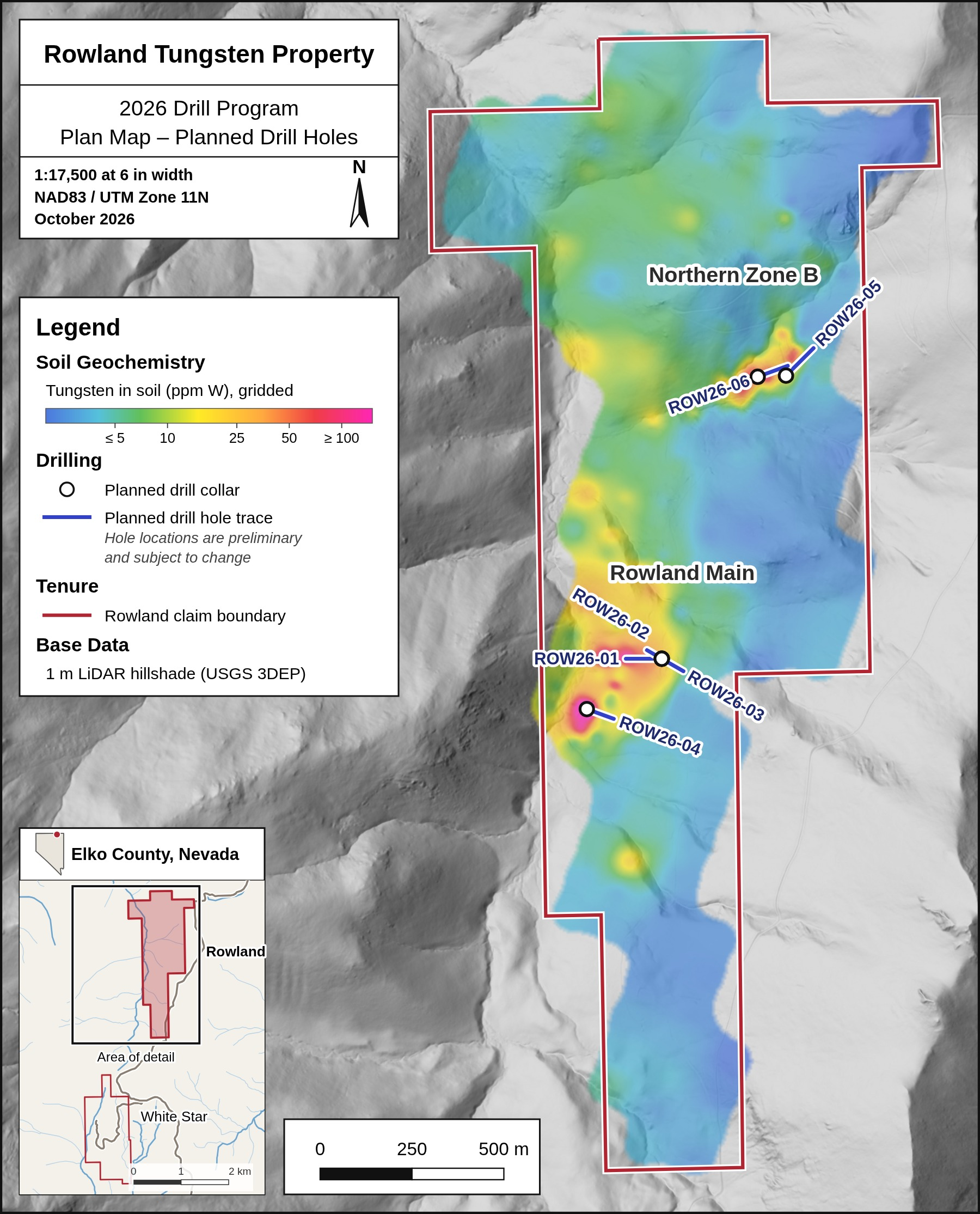
Figure 1: Planned drill holes at the Rowland Tungsten Property over gridded tungsten-in-soil results. Hole locations are preliminary and subject to adjustment pending field verification and permitting.
Drill Target Inventory
The Rowland drill targets were generated from the coincidence of four datasets: the tungsten-in-soil anomalies defined by the Phase 2 soil program, the depth and geometry of contacts modelled by the three-dimensional magnetic inversion, the historical workings confirmed during the Phase 1 program, and the 2026 rock-chip and channel assay results. Holes are oriented to cross the modelled contacts at a high angle wherever the geometry allows. Drill pads were then located on existing roads and trails (Figure 1, Table 1).
The planned drill holes are preliminary in nature. Collar and pad locations, hole orientations and lengths remain subject to adjustment pending field verification, permitting and final program design.
Table 1: Rowland drill targets and planned drilling.
|
Target |
Holes |
Pads |
Footage (ft) |
Section |
Principal targets |
|
Rowland Main |
4 |
2 |
1,850 |
A, B |
Shallow modelled magnetic body beneath the soil anomaly and historical open cut; bedrock source of soil sample R079 |
|
Northern Zone B |
2 |
2 |
1,200 |
C |
Beneath the historical shafts and ore chute; roof of the modelled magnetic body |
|
Total |
6 |
4 |
3,050 |
Rowland Main
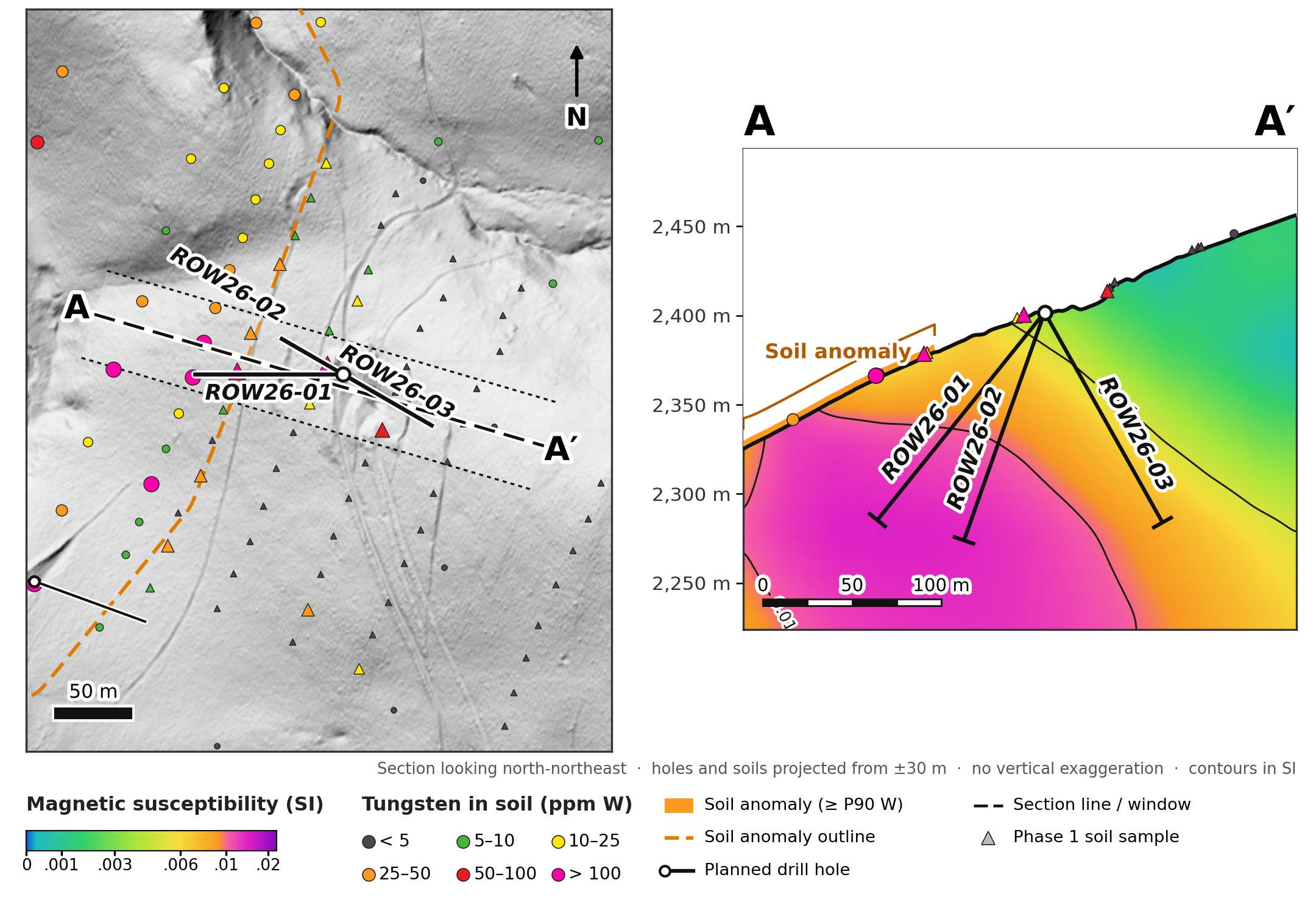
At Rowland Main, the magnetic inversion models a compact magnetic body beneath the core of the soil anomaly and immediately west of the historical open cut, where 2026 rock-chip, float and channel samples returned up to 4.02% WO₃ (sample RO-16-01). Three holes are planned from a single pad on the existing road beside the open cut (RM-PAD-1; Figure 2). ROW26-01 is drilled west at −50° beneath soil samples R119 (373 ppm W) and R120 (109.5 ppm W) and is planned to enter the modelled 0.010 SI contact at approximately 86 metres (282 feet) down-hole. ROW26-02 is drilled west-northwest at −70° into the core of the modelled body, entering the 0.010 SI contact at approximately 76 metres (249 feet) down-hole. ROW26-03 is drilled east-southeast at −60° beneath the open cut and down the eastern margin of the modelled body.
Click Image To View Full Size
Figure 2: Rowland Main – plan and cross-section A–A′ through planned holes ROW26-01 to ROW26-03, with modelled magnetic susceptibility and the soil anomaly.
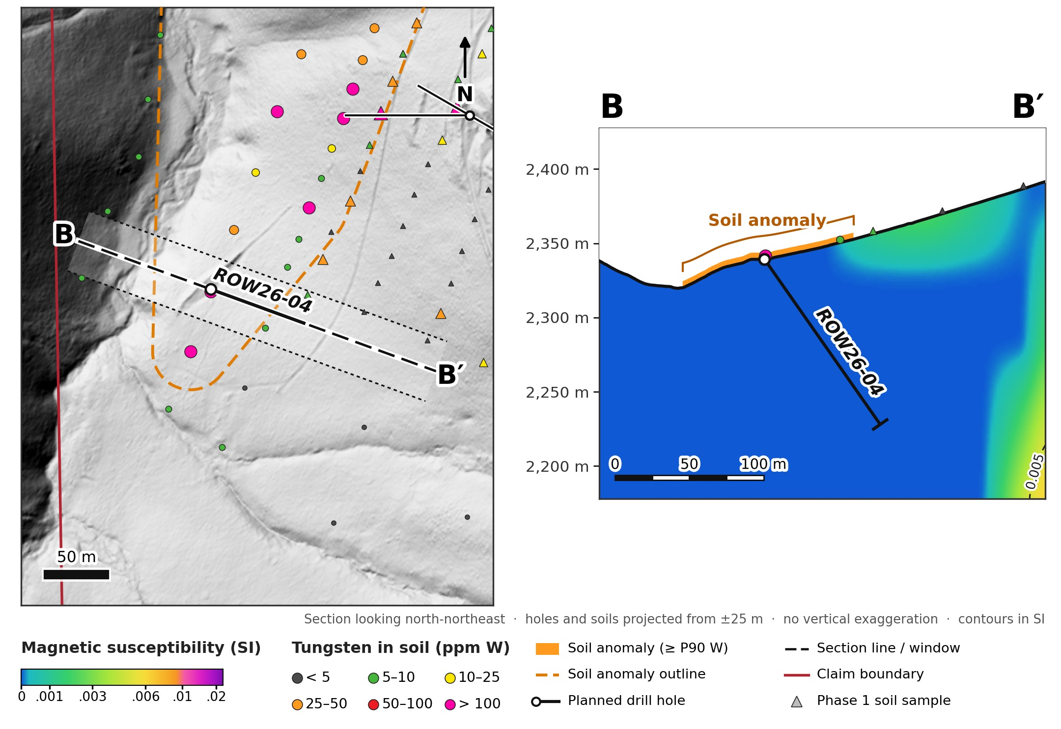
ROW26-04 is collared approximately 250 metres to the south-west (RM-PAD-2), on a historical cut at soil sample R079 (4,240 ppm W; 0.53% WO₃), the highest value returned by the Phase 2 soil program (Figure 3). The hole is drilled east-southeast at −55°, up-slope from the sample, to test for its bedrock source while allowing for down-slope movement of soil.
Click Image To View Full Size
Figure 3: Rowland Main – plan and cross-section B–B′ through planned hole ROW26-04 beneath soil sample R079.
Northern Zone B
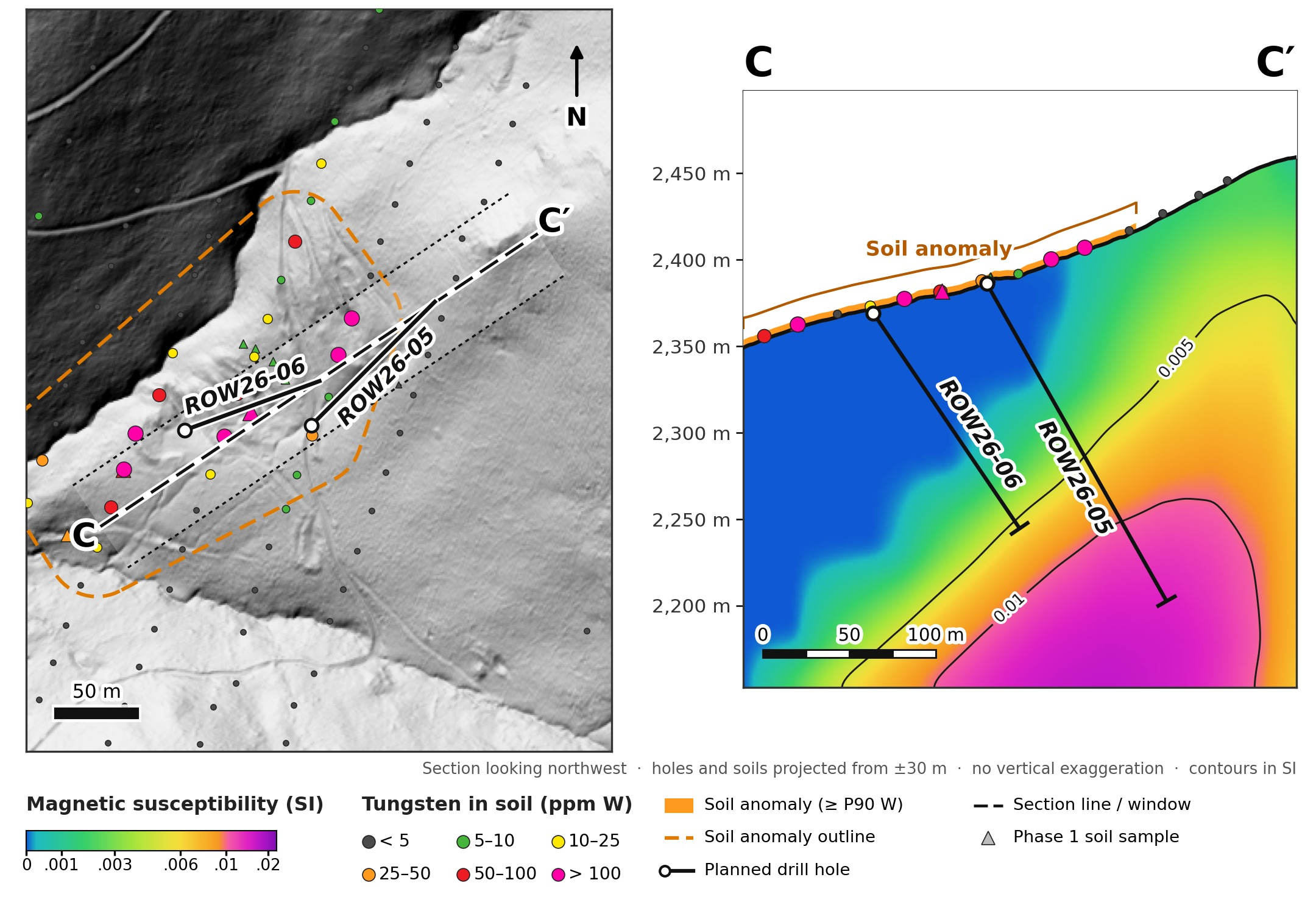
At Northern Zone B, the soil anomaly lies above a larger modelled magnetic body whose roof is modelled at approximately 165 to 210 metres below surface. ROW26-06 is collared on a flat bench within the historical shaft and ore-chute workings (NZB-PAD-1) and is drilled east-northeast at −55° beneath the shafts and soil sample R188 (228 ppm W), in the area where rock-chip samples returned 0.35% to 1.22% WO₃, reaching the outer (0.005 SI) margin of the modelled body near the end of the hole, at approximately 147 metres (482 feet) down-hole. ROW26-05, the longest hole in the program at 700 feet, is collared on the existing track approximately 80 metres to the east (NZB-PAD-2) and is drilled north-east at −60° beneath soil sample R217 (136.5 ppm W) and the north-east-trending trench workings. It is planned to enter the modelled 0.010 SI contact, the roof of the body, at approximately 159 metres (522 feet) down-hole (Figure 4).
Click Image To View Full Size
Figure 4: Northern Zone B – plan and cross-section C–C′ through planned holes ROW26-05 and ROW26-06.
Permitting and Path to Drilling
The Plan of Operations for the proposed drill program is being prepared by KC Harvey Environmental for submission to the U.S. Forest Service, in parallel with the Nevada Bureau of Mining Regulation and Reclamation reclamation permit. Pad locations, access and hole designs remain subject to field verification and permitting. The Company will provide further updates as permitting milestones are reached and the drill program is finalised.
Planned Drill Hole Details
Table 2: Planned drill hole collar locations and orientations, Rowland Tungsten Property.
|
Hole ID |
Target |
Pad |
Easting (m) |
Northing (m) |
Elev. (m) |
Azimuth (°) |
Dip (°) |
Length (ft) |
Length (m) |
Section |
|
ROW26-01 |
Rowland Main |
RM-PAD-1 |
626,364 |
4,630,325 |
2,402 |
270 |
−50 |
500 |
152.4 |
A |
|
ROW26-02 |
Rowland Main |
RM-PAD-1 |
626,364 |
4,630,325 |
2,402 |
300 |
−70 |
450 |
137.2 |
A |
|
ROW26-03 |
Rowland Main |
RM-PAD-1 |
626,364 |
4,630,325 |
2,402 |
120 |
−60 |
450 |
137.2 |
A |
|
ROW26-04 |
Rowland Main |
RM-PAD-2 |
626,160 |
4,630,188 |
2,339 |
110 |
−55 |
450 |
137.2 |
B |
|
ROW26-05 |
Northern Zone B |
NZB-PAD-2 |
626,702 |
4,631,095 |
2,386 |
045 |
−60 |
700 |
213.4 |
C |
|
ROW26-06 |
Northern Zone B |
NZB-PAD-1 |
626,625 |
4,631,092 |
2,369 |
070 |
−55 |
500 |
152.4 |
C |
|
Total |
3,050 |
929.6 |
Coordinates are NAD83 / UTM Zone 11N; elevations from USGS 3DEP 1 m LiDAR. Planned holes are preliminary and subject to adjustment pending field verification and permitting.
Technical Notes
No new assay results are reported in this news release. Soil, rock-chip, float and channel sample results referred to in this news release have been previously disclosed by the Company. Soil geochemical values represent surficial dispersion and are not, and should not be interpreted as, indicative of grade or of any mineral resource. Soil anomalies are defined at the 90th percentile of the routine Phase 2 soil population (21.1 ppm W for the Rowland survey). Rock-chip and float samples are selective by nature and are not necessarily representative of the mineralisation. WO₃ values are calculated from elemental tungsten (W) using a conversion factor of 1.2611.
Gridded tungsten-in-soil images were generated from the Phase 2 soil results by inverse-distance weighting of log-transformed tungsten values on a 5-metre grid, limited to within approximately 60 metres of a sample. The grids are presented to illustrate the distribution of tungsten in soil and are not, and should not be interpreted as, estimates of grade.
The three-dimensional magnetic inversion was completed by East Coast Consulting from the Company’s 2026 UAV magnetic survey and models magnetic susceptibility in 25-metre cells. Modelled susceptibility contacts are interpretations of a non-unique geophysical model rather than direct observations of geology, and their position and depth may differ from those encountered in drilling. Down-hole depths to modelled contacts quoted in this news release are measured along the planned hole from the collar and are approximate.
Qualified Person
The scientific and technical information contained in this news release has been reviewed and approved by Jasper Mowatt, MIMMM (Membership No. 0486653) and MAusIMM (Membership No. 3178851), a consultant to the Company and a Qualified Person as defined by National Instrument 43-101 – Standards of Disclosure for Mineral Projects. Mr. Mowatt is not independent of the Company.
ENGAGEMENT OF PANAM MARKETING INC. FOR INVESTOR AWARENESS SERVICES
The Company announces that it has engaged PanAm Marketing Inc. ("PanAm") to provide digital investor awareness and marketing services. Pursuant to a Master Services Agreement dated September 30, 2026 and a related statement of work, PanAm will provide digital investor awareness services to the Company, including programmatic digital advertising, content development, campaign landing pages, and coordination with third-party publishers and content creators. The services are expected to be delivered across online advertising networks, financial and investment websites, social media platforms, email newsletters, and third-party publisher and content-creator channels. The promotional activity is expected to commence on or about October 15th, 2026 and to conclude on or about November 15, 2026. Following the initial term, the engagement continues on a month-to-month basis unless terminated by either party on thirty days' written notice. In consideration for the services, the Company has agreed to pay PanAm total compensation of CAD $60,000.00, payable in cash in advance as a campaign budget allocation. The budget will be applied to PanAm's fees for services and to third-party media, publisher, platform, and content creator costs incurred in delivering the campaign. No securities, options, warrants, success fees, or other equity-based or performance-based compensation are payable to PanAm. PanAm's compensation is not based on the trading price, trading volume, or market performance of the Company's securities, or on the completion of any financing. PanAm's contact information is as follows: CSE POLICY 5 / 7 PANAM PanAm Marketing Inc. 5728 East Blvd., Vancouver, British Columbia V6M 4M4, Canada Email: accounts@panam.marketing Phone: 780-257-4680 To the knowledge of the Company, neither PanAm nor any of its principals holds any securities of the Company as at the date of this news release. PanAm and its principals have agreed not to purchase, sell, or short sell securities of the Company from the date of the engagement until thirty days after the conclusion of the campaign. PanAm is at arm's length to the Company. PanAm is not a registered adviser or dealer and does not provide investment advice or make securities recommendations. All promotional materials produced under the engagement will disclose that PanAm has been compensated by the Company, in accordance with applicable securities laws, the policies of the Canadian Securities Exchange, and BC Instrument 51-519 — Promotional Activity Disclosure Requirements. Promotional content will be based on the Company's public disclosure record and will not contain any prediction, projection, or forecast of the trading price or trading volume of the Company's securities.
About Western Star Resources
Western Star Resources is a mineral exploration company focused on the acquisition, exploration and advancement of mineral properties, with a growing strategic emphasis on tungsten and critical minerals in the United States. The Company is advancing a portfolio of past-producing tungsten assets in Nevada and New Mexico while maintaining additional exploration exposure through its Western Star property in British Columbia.
PANAM tungsten mineralization; the advancement of the Company’s U.S. tungsten properties, including the potential development of Eagle Point as a U.S. source of tungsten; and the Company’s exploration and corporate strategy. Forward-looking information is based on assumptions considered reasonable by management at the date such statements are made and is subject to known and unknown risks, uncertainties and other factors that may cause actual results to differ materially from those expressed or implied. There can be no assurance that exploration will result in the discovery or delineation of a mineral resource, that proposed exploration or drilling will be completed as contemplated, or that any mineralization identified will prove economically recoverable.
Contact Information:
Blake Morgan,
Director, President and CEO
blake@acvc.vc
Neither the Canadian Securities Exchange nor its Regulation Services Provider (as that term is defined in the policies of the Canadian Securities Exchange) accepts responsibility for the adequacy or accuracy of this press release.
Certain of the statements made and information contained herein may constitute “forward-looking information”. In particular, references to drill targets, the planned drill program, its design, timing, permitting, financing and completion, the interpretation of geophysical models, and future work programs or expectations on the quality or results of such work programs are subject to risks associated with operations on the property, exploration activity generally, permitting, equipment limitations and availability, as well as other risks that the Company may not currently be aware of. Accordingly, readers are advised not to place undue reliance on forward-looking information. Except as required under applicable securities legislation, the Company undertakes no obligation to publicly update or revise forward-looking information, whether as a result of new information, future events or otherwise.
