Archive
Hi-View Completes Comprehensive Data Room Compilation
 | |||||||||
 |  | ||||||||
VANCOUVER, BRITISH COLUMBIA, APRIL 21, 2026 - TheNewswire – HI-VIEW RESOURCES INC. (“Hi-View” or the “Company”) (CSE: GXLD; OTCQB: HVWRF; FSE: B630) announces the successful completion of its data room compilation in connection with its portfolio of properties in the Toodoggone District. The data room has been assembled to support potential partnerships, joint ventures, or asset-level investment discussions.
“After months of dedicated effort, we have completed a comprehensive data room that will help unlock the full value of our Toodoggone portfolio,” commented R. Nick Horsley, Chief Executive Officer of Hi-View.
“With over 10,000 digitized samples, kilometers of IP data, and newly uncovered historic drill logs now compiled and geo-referenced, we have assembled one of the largest historical datasets in the district. This robust dataset will enable our team to identify additional high-priority targets for the upcoming field season.
Through our M&A activities in 2025, the equivalent exploration work represented in the data room would exceed $10 million at today’s costs. As the data room continues to expand, it will significantly accelerate our ability to define priority drill targets, attract strategic investments, and pursue potential joint ventures.”
“This is a fundamental preliminary stepping stone in transforming a fragmented historical dataset into a cohesive, high-confidence exploration platform,” commented Nader Mostaghimi, VP Exploration.
“By integrating and validating decades of geological, geochemical, and geophysical data, we are now in a position to significantly reduce exploration risk and more efficiently vector toward high-priority drill targets. This work not only strengthens our technical understanding of the district, but also enhances our ability to attract strategic partners and unlock the full value of our Toodoggone portfolio.”
Data Room Overview
The data room has been compiled over the past several months and encompasses all geologically relevant material pertaining to the Golden Stranger, Lawyers Claims, Borealis, Saunders, Northern Claims, Nub, and Harmon Peak projects. The repository includes, but is not limited to:
-
A consolidated data compilation prepared in conjunction with APEX Geoscience, summarizing all technical work completed on the property to date.
-
A centralized PostgreSQL database designed to house all historical and future exploration data, enhancing data integrity, security, and accessibility.
-
Peer-reviewed academic literature and scientific papers examining the regional geological setting and mineralization controls.
-
Historical property maps illustrating the spatial extent and key geological features of the project area.
-
High-level project summary reports providing an accessible overview of exploration findings and development potential.
-
A full suite of documentation including assessment reports, Minfiles, NI 43-101 technical reports, and corporate press releases.
Access to the data room is available to qualified strategic partners and investors. To request access or for further information, please contact Nick Horsley directly.
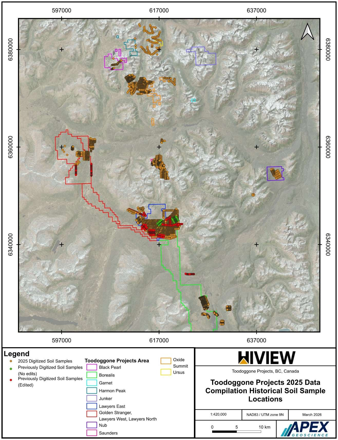
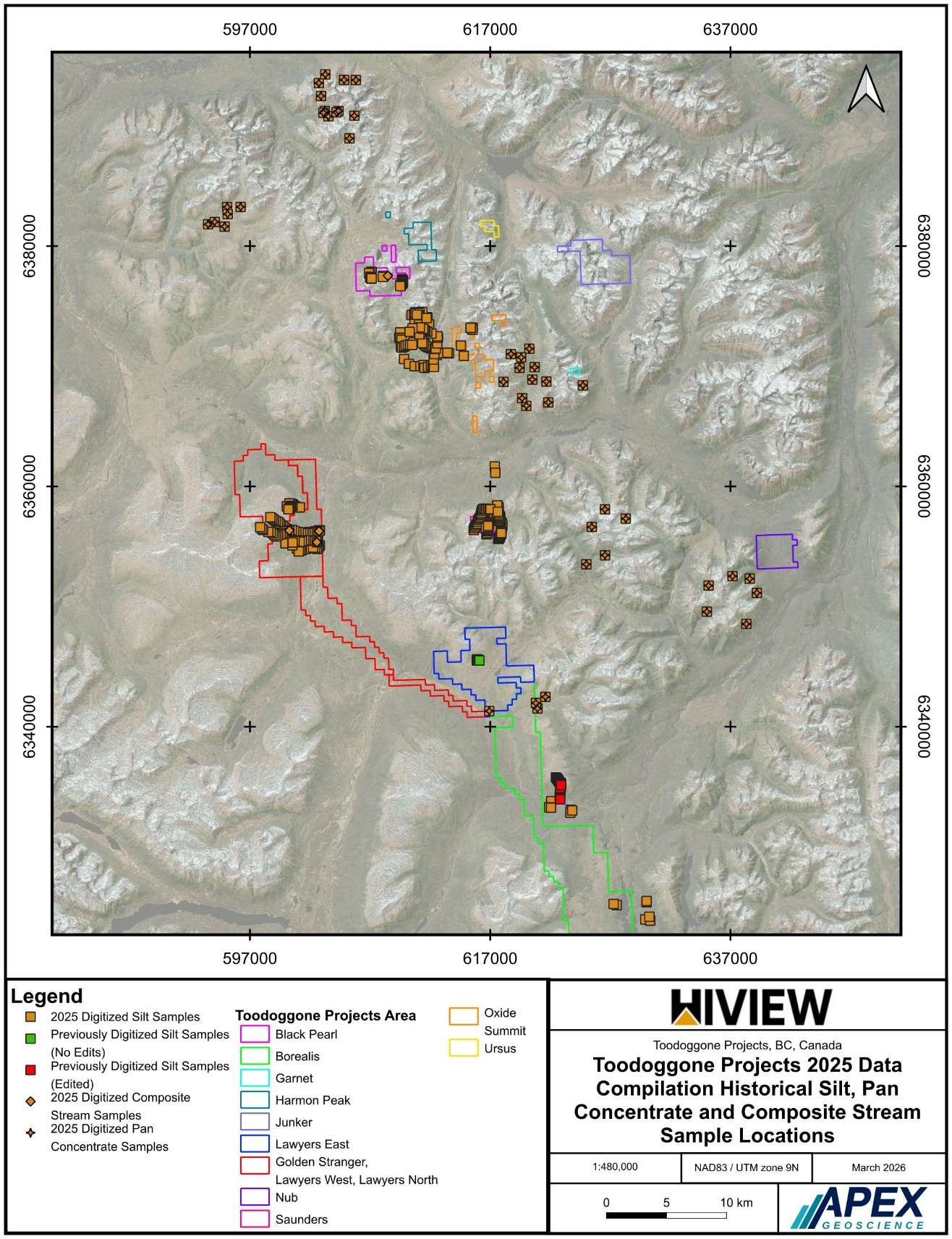
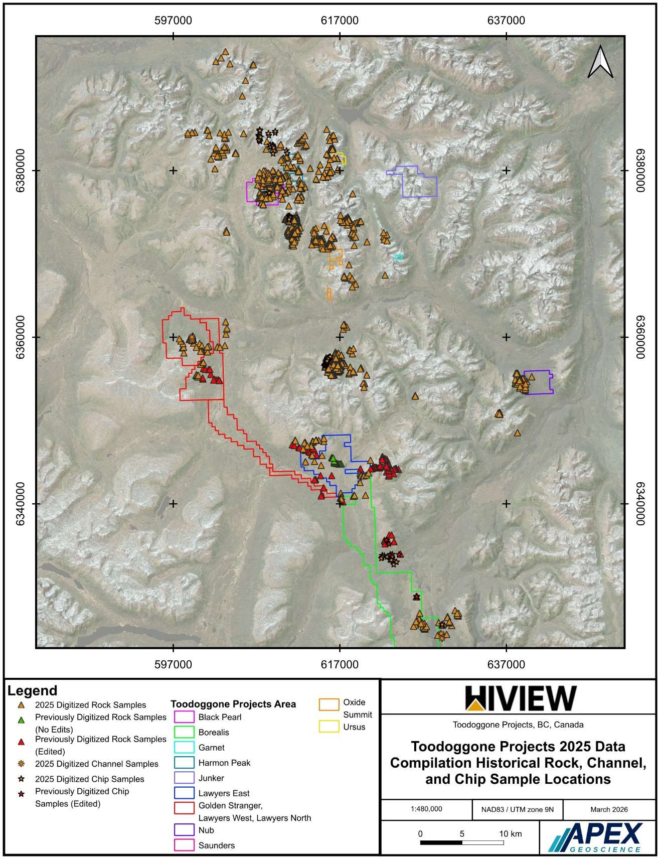
A total of 58 assessment reports were digitized and compiled. This included 8,375 soils, 417 silt samples, 45 pan concentrate samples, 9 composite stream samples, 1,759 rocks, 173 chips, and 153 channel samples. Of these, 8,300 soils and 1,724 rocks carry confirmed location data and are represented in the sample location figures (Figures 1–3).
Of previously digitized samples, 479 soils were edited, 206 required no edits; 23 silts were edited, 7 required no edits; 111 rocks were edited, 17 required no edits; and 19 chip samples were edited.
Click Image To View Full Size
Figure 1. Historical Soil Sample Locations
Click Image To View Full Size
Figure 2. Historical Silt, Pan Concentrate, and Composite Sample Locations
Click Image To View Full Size
Figure 3. Historical Rock, Chip, and Chanel Sample Locations
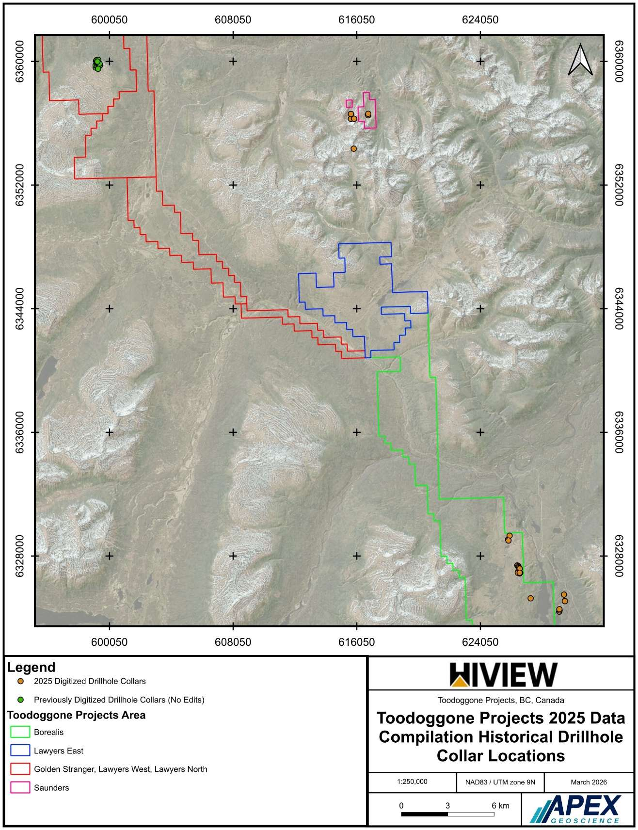
A total of 60 drillholes, including those within our boundaries and in the surrounding area, along with 2,084 drill samples, are included in this data compilation. Of the 60 drillholes 29 collars were previously digitized and required no edits and the remaining 31 were newly digitized. Collar locations are presented in Figure 4.
Click Image To View Full Size
Figure 4. Historical Drillhole Collar Locations
Priority Targets
Three properties anchor the Hi-View Toodoggone portfolio as high-priority drill targets, each with distinct geological characteristics and well-defined exploration histories.
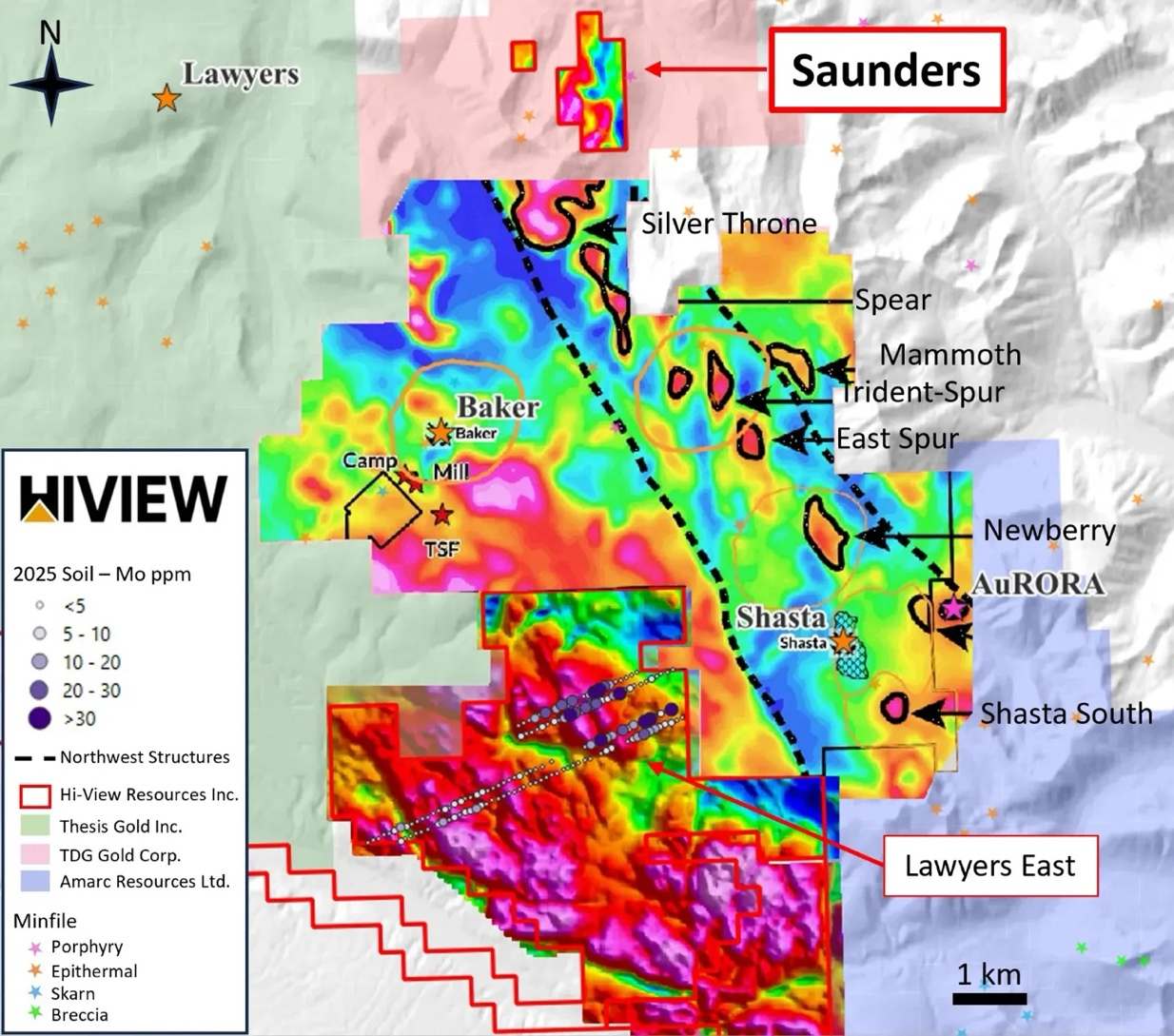
Lawyers East Property
Eight assessment reports spanning 1973 to 2023 were digitized, encompassing approximately 2,800 soil samples, 300+ rock and chip samples, and 8 silt samples. Previously digitized data from several reports was reviewed and corrected for geochemical transcription errors and location discrepancies. Oz/T assay values from Chemex labs were converted to g/t across multiple reports. Location confidence is generally moderate, with some reports benefiting from GPS coordinates providing high confidence placements.1
Click Image To View Full Size
Figure 5. Lawyers East Project with Aeromagnetic (2025 program) and Soil Sampling with Mo grades.
Borealis Property
9 assessment reports spanning 1973 to 1996 were digitized, encompassing over 1,300 soil samples, 100+ rock and chip samples, 23 silt samples, and 1 composite stream sample. The compilation also includes 14 historical drillholes from Granby Mining Company (1957 and 1968) and 8 BQ diamond drillholes with 215 sample intervals from 1984. Geochemical data includes assays for Au, Ag, Cu, Pb, and Zn. Location confidence for the earlier reports is moderate to lower due to the use of small-scale regional and hand-drawn maps for georeferencing.2
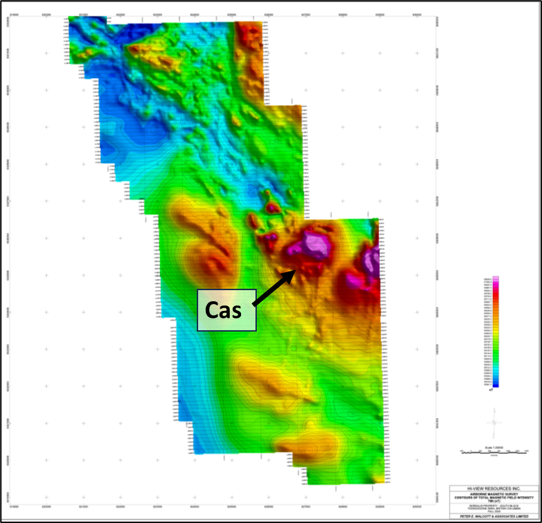
Figure 6. Borealis with Aeromagnetic (2025 program) with Cas Target.
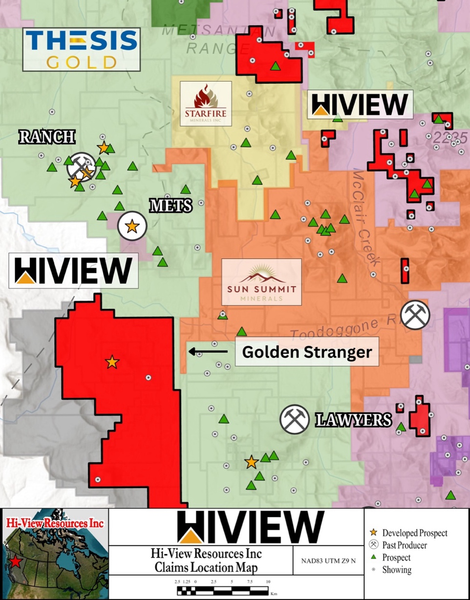
Golden Stranger Property
11 assessment reports spanning 1980 to 2024 were digitized, encompassing approximately 850 soil samples, 150+ rock and channel samples, 50+ stream sediment samples, and 29 diamond drillholes with over 1,380 downhole sample intervals. Key drill intercepts within this dataset include GS017 returning 1,820 ppb Au over 1.8 m, 910 ppb Au over 1.8 m, and 850 ppb Au over 2.1 m. Location confidence is generally moderate to high, with recent field data provided as GPS coordinates requiring no georeferencing.3
Click Image To View Full Size
Figure 7. Golden Stranger Project
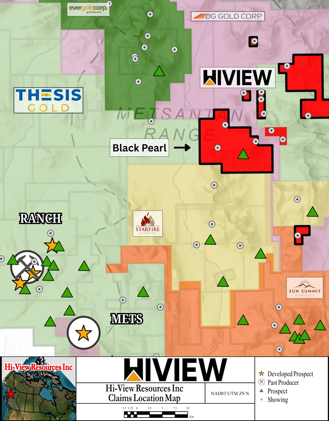
Black Pearl Property
Six assessment reports spanning 1983 to 2016 were digitized, encompassing approximately 67 soil samples, 29 silt samples, and 475 rock and chip samples. The compilation includes XRF analysis for 10 rock samples from Assessment Report #36069 (2016). Location confidence ranges from moderate to high, with more recent reports benefiting from UTM coordinates, though blurry scan quality in several reports introduces minor transcription uncertainty. The majority of samples fall within or proximal to the currently held Hi-View claims of the Black Pearl zone.4
Click Image To View Full Size
Figure 8. Black Pearl Project
The compilation of this data room represents a significant milestone for Hi-View Resources, reflecting the depth and quality of historical exploration work conducted across the Toodoggone District. With over 10,000 digitized samples, 60 georeferenced drillholes, and 58 assessment reports compiled across multiple project areas, the Company believes this dataset provides a compelling foundation for advancing its portfolio toward its next phase of exploration. Hi-View remains committed to unlocking the full potential of its Toodoggone assets and welcomes dialogue with qualified partners and investors who share its vision for the district.
Qualified Person’s Statement
The technical content of this news release has been reviewed and approved by Marilyne Laccasse, P.Geo., a consultant for the Company and a Qualified Person as defined by National Instrument 43-101.
About Hi-View Resources Inc.
Hi-View Resources Inc., a publicly listed mineral exploration company on the Canadian Securities Exchange, is advancing a portfolio of gold, silver, and copper assets in the Toodoggone region of northern British Columbia. The Company’s 100% owned and optioned projects cover more than 27,910 hectares and include the flagship Golden Stranger Project, the Lawyers claims, and the Borealis Project — all designated as high-priority targets. Additional properties under option include Saunders, Northern Claims, Nub, and Harmon Peak. The company also has an additional 1,300 hectares currently under mineral claim application. For more information, please visit Hi-View’s website or review the Company’s filings on SEDAR+ (www.sedarplus.ca).
On Behalf of the Board of Directors,
“R. Nick Horsley”
R. Nick Horsley, CEO
For further information, please contact:
Hi-View Resources Inc.
R. Nick Horsley - CEO
Email: info@hiviewresources.com
Telephone: (604) 377-8994
Website: www.hiviewresources.com
FORWARD LOOKING STATEMENTS:
This news release includes certain statements that may be deemed “forward-looking statements”. All statements in this new release, other than statements of historical facts, that address events or developments that the Company expects to occur, are forward-looking statements. Forward-looking statements are statements that are not historical facts and are generally, but not always, identified by the words “expects”, “plans”, “anticipates”, “believes”, “intends”, “estimates”, “projects”, “potential” and similar expressions, or that events or conditions “will”, “would”, “may”, “could” or “should” occur. Forward-looking statements in this news release includes statements related to the Incentive Program and the anticipated use of proceed therefrom. Although the Company believes the expectations expressed in such forward-looking statements are based on reasonable assumptions, such statements are not guarantees of future performance and actual results may differ materially from those in the forward-looking statements. Factors that could cause the actual results to differ materially from those in forward-looking statements include market prices, continued availability of capital and financing, and general economic, market or business conditions. Investors are cautioned that any such statements are not guarantees of future performance and actual results or developments may differ materially from those projected in the forward-looking statements. Forward-looking statements are based on the beliefs, estimates and opinions of the Company’s management on the date the statements are made. Except as required by applicable securities laws, the Company undertakes no obligation to update these forward-looking statements in the event that management's beliefs, estimates or opinions, or other factors, should change.
The Canadian Securities Exchange has neither approved nor disapproved the contents of this news release.
WE SEEK SAFE HARBOUR
1 BC Ministry of Energy, Mines and Low Carbon Innovation, Assessment Reports #4570 (1973), #11525 (1983), #12979 (1984), #16368 (1987), #16369 (1987), #16370 (1987), #18026 (1988), and #41823 (2023). Available through the BC MINFILE Assessment Report database.
2 BC Ministry of Energy, Mines and Low Carbon Innovation, Assessment Reports #4200 (1973), #9000 (1980), #13022 (1984), #13025 (1984), #16371 (1987), #17452 (1988), #18241 (1988), #22721 (1992), and #25003 (1996). Available through the BC MINFILE Assessment Report database.
3 BC Ministry of Energy, Mines and Low Carbon Innovation, Assessment Reports #9392 (1980), #11793 (1983), #13930 (1985), #15165 (1986), #15633 (1987), #17000 (1988), #17288 (1987), #17456 (1988), #18334 (1989), #40049 (2022), and #42200 (2024). Available through the BC MINFILE Assessment Report database.
4 BC Ministry of Energy, Mines and Low Carbon Innovation, Assessment Reports #11791 (1983), #15474 (1987), #27635 (2005), #28036 (2005), #29309 (2007), and #36069 (2016). Available through the BC MINFILE Assessment Report database.