
Archive
Red Canyon Provides Conclusions of Independent Vectoring Study and Exploration Update for its 100% Owned Kendal Copper Project
 | |||||||||
 |  |  | |||||||
Vancouver, British Columbia - TheNewswire - September 23, 2026: Red Canyon Resources Ltd. (“Red Canyon” or the “Company”) (CSE: REDC | OTCQB: REDRF| Frankfurt: I91) is pleased to provide an exploration update for its 100% owned Kendal Copper Project located in west-central British Columbia. The Company has completed an extensive technical review and launched an expanded field program to aggressively fast-track expansion drill targeting.
Company Highlights:
-
Independent Vectoring Study Received: The Company has received a comprehensive, multi-dataset evaluation study focused on porphyry vectoring utilizing project-wide geophysics, geochemistry, and structural data. The independent evaluation identifies the project as highly prospective, and the untested Ridge Breccia and Express Corridor (K-Core) areas as high-priority within the Kendal porphyry system, with the interpreted potassic core of the system remaining untested by drilling.
-
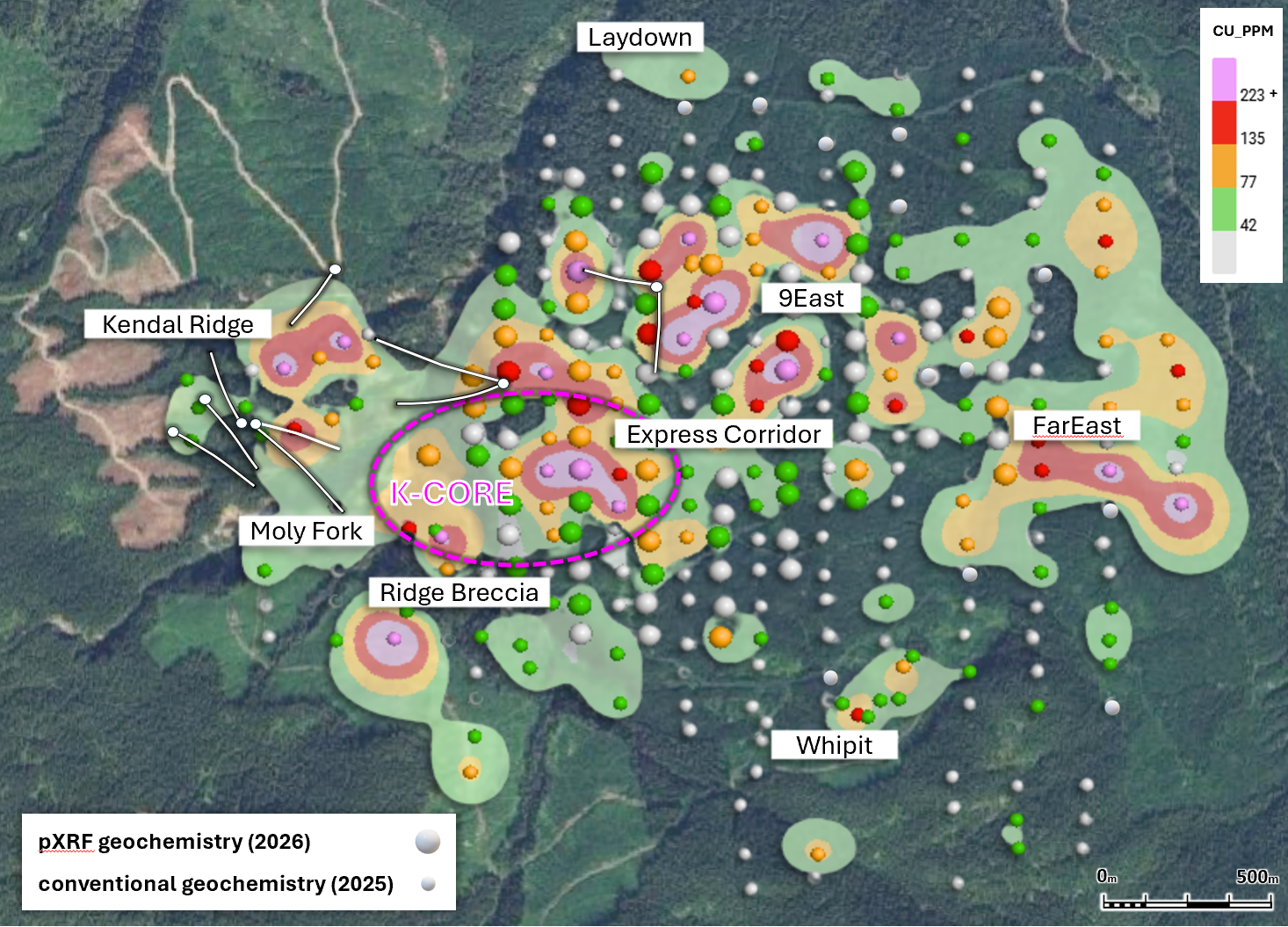
The Company completed infill soil sampling targeting geochemistry across the Ridge Breccia, Express Corridor, 9East and FarEast target areas (Figure 6). Preliminary in-field portable X-ray fluorescence (pXRF) analysis continues to outline a significant trend of anomalous copper and other porphyry-indicator elements, with the strongest responses associated with the Ridge Breccia, Express Corridor, and 9East target areas.
-
Red Canyon has finalized a survey agreement with SJ Geophysics Ltd. to complete a project-wide, high-resolution three-dimensional Induced Polarization (“3DIP”) survey. The survey began in mid-September 2026 and is designed to improve the definition and prioritization of future drill targets across the Kendal system.
-
The 3DIP program will utilize SJ Geophysics’ proprietary Volterra Distributed Acquisition System and an advanced multi-line Diamond Array configuration to generate high-resolution three-dimensional models of resistivity and chargeability across the project’s principal target areas.
Wendell Zerb, the Chairman and CEO of the Company, states: “We are very encouraged by the conclusions of the independent vectoring study and the results of our expanded geochemistry program at Kendal. The study has significantly advanced our understanding of this large porphyry system and, importantly, identifies the Ridge Breccia and Express Corridor as central components of the system that have yet to be drill tested.
Our preliminary pXRF results also provide strong support for this interpretation, with a significant copper and porphyry-indicator geochemical trend extending across the project and the strongest responses occurring around the Ridge Breccia and Express Corridor. The combination of geochemistry, magnetics, conductivity and geological information from previous drilling provides a compelling framework for our next phase of exploration.
We are now advancing a project-wide 3DIP survey with SJ Geophysics to better define the subsurface chargeability and resistivity architecture of the Kendal system. This survey is designed to provide a much more detailed three-dimensional understanding of the system to help identify the highest-priority locations for future drilling.”
Red Canyon Projects
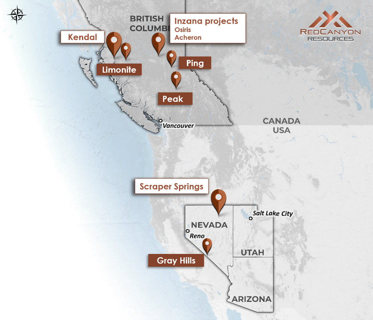
The Company holds a portfolio of seven 100% owned1 projects in British Columbia and Nevada. High-priority projects are Kendal in west-central British Columbia, Inzana (Osiris and Acheron) in central British Columbia and Scraper Springs in northeast Nevada.
Click Image To View Full Size
Figure 1: Location map of Red Canyon’s 100% owned1 copper and copper-gold projects.
Kendal Project
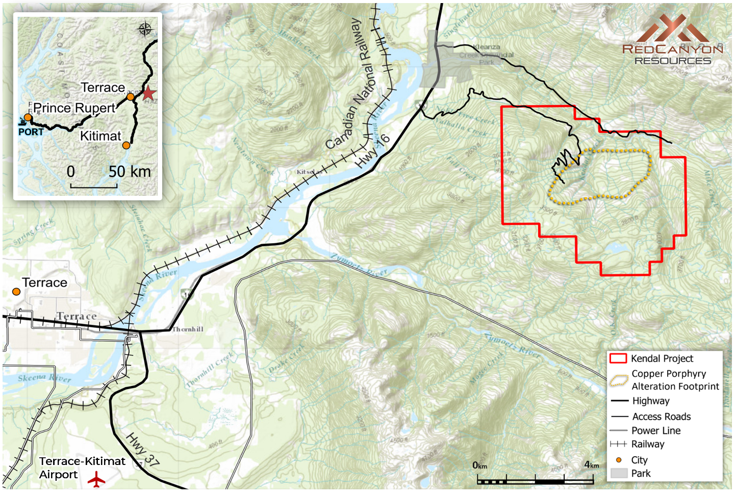
Kendal comprises five 100%-owned mineral claims totaling approximately 2,738 hectares located in west-central British Columbia, approximately 25 km northeast of Terrace, British Columbia. The project is situated within a well-established infrastructure corridor with access to highways, hydroelectric power, rail and port facilities. The main project area has direct logging road access approximately 8 km east of Highway 16, providing excellent access for exploration and potential future development activities. The project area lies within the traditional territory of the Kitselas First Nation.
Kendal hosts a large-scale copper-molybdenum-gold-silver hydrothermal system interpreted to extend approximately 4 km x 3 km. Previous drilling has tested only a relatively small portion of this system.
The initial diamond drilling in 2024 and 2025 identified widespread hydrothermal alteration and porphyry-style quartz-sulphide veining throughout the drill holes, with variable copper and molybdenum mineralization. Follow-up work in 2025, including detailed geological mapping, lithogeochemistry, expanded soil geochemistry, vein-density studies and airborne Mobile Magneto-Telluric (“MMT”) geophysics, further refined the geological model and identified multiple priority target areas.
Click Image To View Full Size
Figure 2: Kendal project location and infrastructure map with Red Canyon claims.
Independent Vectoring Study
Red Canyon has received a comprehensive, data-integrated Technical Evaluation Report for the Kendal Project compiled by independent porphyry specialist Juan Soto (Geological Engineer/MBA Mining Management). The report synthesizes surface geology, rock and soil geochemistry (ioGAS), drill core Short-Wave Infrared (SWIR) spectral mineralogy, and airborne geophysics to deliver a fundamentally revised geological model for the property.
The technical review concludes that Red Canyon’s initial 10-hole diamond drilling campaigns in 2024 and 2025 successfully tested the outer phyllic to phyllic-propylitic pyrite halo of the system, which explains the widespread anomalous iron and sulphur, but lower copper-molybdenum grades encountered to date. Importantly, advanced SWIR spectral vectoring tracking progressively increasing white mica crystallinity towards the east-southeast and trace element paths suggest that previous drilling closely approached, but has not yet penetrated, the true centre of the hydrothermal system.
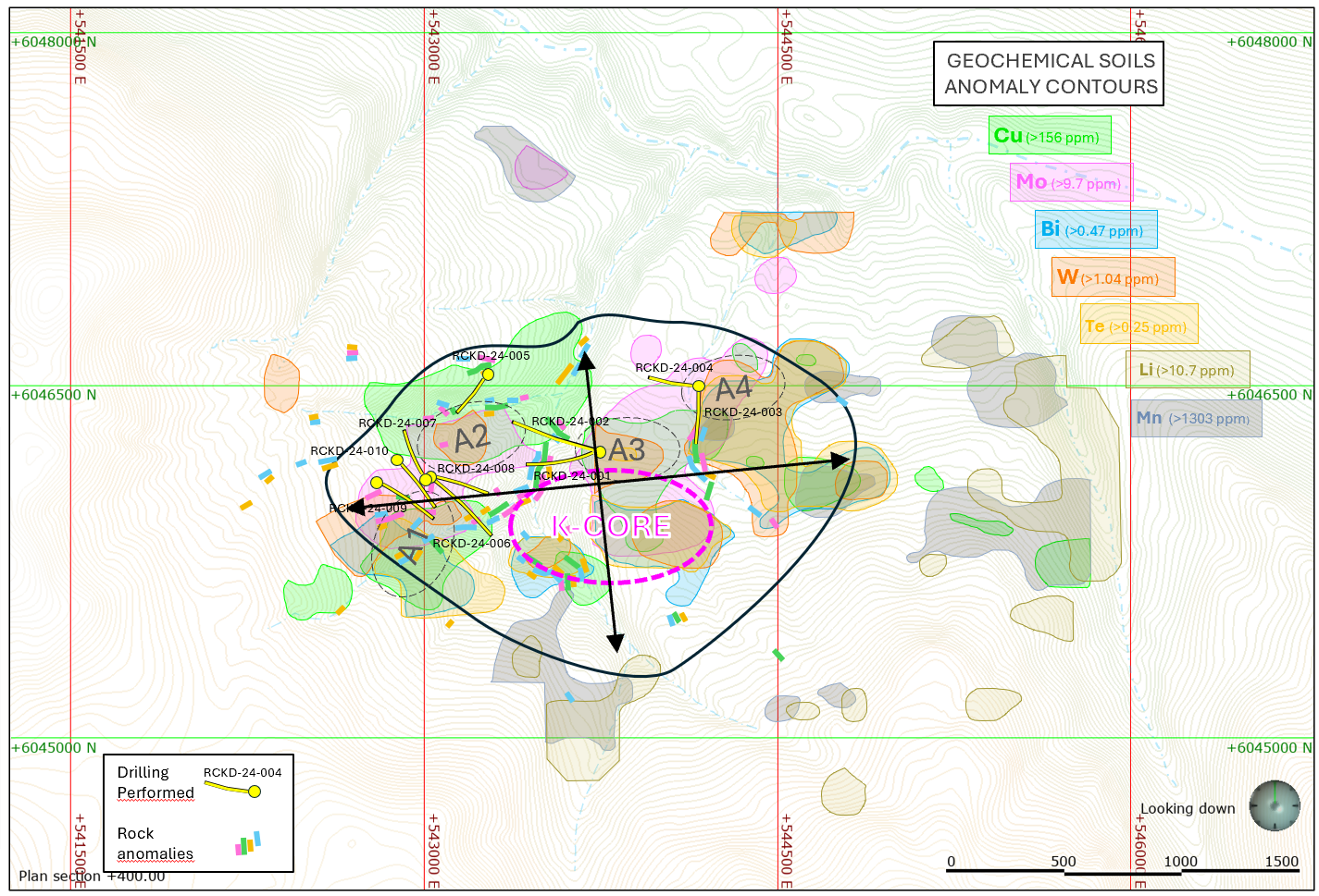
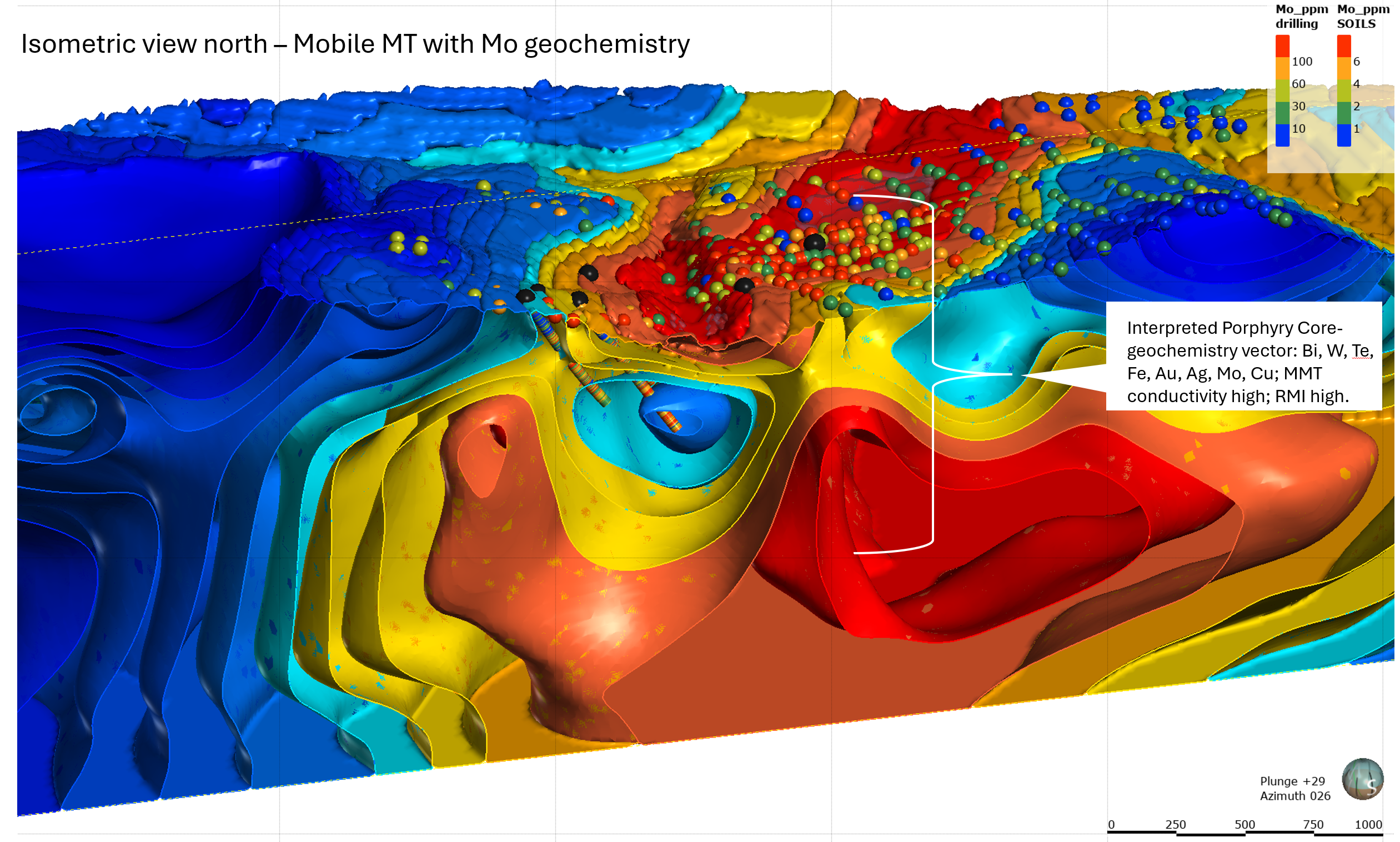
The study defines the Kendal project as highly prospective, with highest-priority K-Core (Express Corridor) target area, an interpreted potassic core of the porphyry system. This area remains completely untested by drilling. The primary target zone is defined by a coincident approximately 600 m x 500 m multi-element soil anomaly, including bismuth, tungsten, tellurium, iron, gold, silver, molybdenum and copper, directly associated with a strong Remanent Magnetic Intensity (RMI) magnetic anomaly and a major subsurface high-conductivity body. The study suggests that this geophysical and geochemical overlap is characteristic of a developed, preserved potassic core potentially hosting copper-sulphide stockwork mineralization (Figures 3 and 4).
Click Image To View Full Size
Figure 3: Independent review highlighting geochemical zonation at Kendal. Zones A1-A4 identified as peripheral clusters within an intermediate to distal pyritic halo. K-core area (Express Corridor) defined by coincident Mo, Bi, W, Cu, Au, Te, and Se element suite is interpreted as proximal pathfinder elements defining a potential potassic core.
Click Image To View Full Size
Figure 4: Isometric view looking north showing MMT isosurfaces with Mo-in-soil geochemistry as spheres. Interpreted porphyry core.
The independent technical evaluation integrated the following key datasets to reach its conclusions:
Geochemical Data: The evaluation analyzed surface rock sample geochemistry (~590 samples) and soil sample geochemistry (936 samples) combined with multivariate ioGAS processing of pathfinder elements including copper, molybdenum, bismuth, tungsten, tellurium, iron, gold, and silver. Downhole geochemistry from 10 diamond drill holes was also reviewed.
Geophysical Data: The study analyzed airborne RMI magnetometry to map magnetic signatures alongside MMT airborne geophysics to measure sub-surface resistivity and conductivity.
Mineralogical Data: SWIR spectrometer data from drill core was used to evaluate white mica absorption wavelengths (Al-OH) and crystallinity indices (2200X) to map hydrothermal zoning.
Geological Data: The study integrated surface geology observations and drill logs from the 2024 and 2025 diamond drilling campaigns.
2025-26 Soil Geochemistry Programs
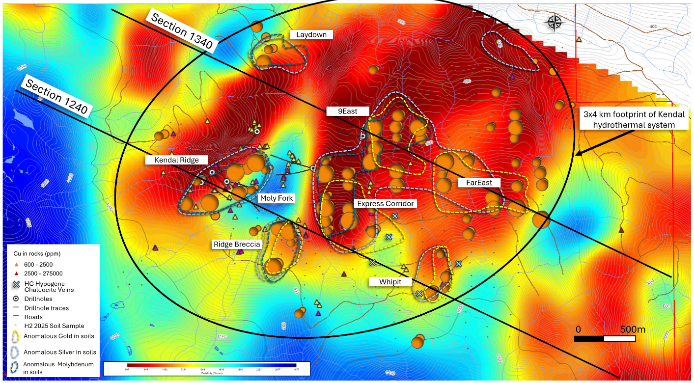
In the second half of 2025, the Company completed a large-scale soil geochemistry program consisting of 252 samples to target areas with limited or variable rock exposure at Kendal (Figures 5 and 6). Copper-in-soil anomalism occurs over several zones within a 2.6 km x 0.9 km area. Within that area lies a 1.6 km x 0.8 km zone of moly-in-soil anomalism and several, mostly coincident zones with silver and gold-in-soil anomalism. Soil sampling identified several new anomalies, some of which have coincident conductivity features from the MMT geophysical survey results, that when combined, distinguish new high-priority targets.
Click Image To View Full Size
Figure 5: 2025 soil geochemistry survey results with highlighted Cu anomalies as circles and Mo, Au and Ag contours, underlain by geophysical MMT resistivity raster at 200 masl emphasizing coincident low resistivity (high conductivity).
2025 soil samples were collected over a 200 m x 100 m spaced grid and preferentially collected from lowermost B-horizon of the soil profile.
To improve geochemical resolution and provide additional coverage across the Kendal system, Red Canyon recently completed an additional 98 soil samples to infill a 100 m by 100 m grid area, associated with the Ridge Breccia, Express Corridor (K-Core), 9East and FarEast target areas (Figure 6). In both surveys samples were collected using a hand auger to approximately 50 cm depth, below the organic-rich surface layer.
Preliminary field pXRF analysis has further outlined the significant trend of anomalous copper and other porphyry-indicator elements across the Kendal system. The strongest preliminary responses are associated with the Ridge Breccia, Express Corridor (K-Core), and 9East target areas. The Ridge Breccia and Express Corridor are closely associated with the K-Core zone identified as the priority target by the independent vectoring study.
The pXRF results are considered preliminary field screening data and are being used to identify and refine areas of geochemical interest. All soil samples have been submitted to AGAT Laboratories for analysis by ICP-OES/ICP-MS finish for 51 elements including gold, with assay results pending.
Click Image To View Full Size
Figure 6: Kendal target areas showing the 2025 soil sample locations and 2026 soil sample locations with preliminary pXRF copper analyses for Ridge Breccia, Express Corridor, 9East and FarEast target areas.
Ridge Breccia and Express Corridor
The Ridge Breccia and Express Corridor areas tightly overlap the K-Core area identified by the independent vectoring study.
The Ridge Breccia area is characterized by a combination of elevated copper and other porphyry-indicator elements, magnetic responses and geological evidence of hydrothermal brecciation and mineralization. The Express Corridor represents a major geochemical and geophysical trend interpreted as forming an important component of the Kendal hydrothermal system.
Ridge Breccia – This 0.4 km x 0.4 km zone is bounded by a northwest-trending drainage and a north-northeast-trending drainage, both of which are interpreted to be long-lived structures. The area has coincident elevated copper-moly-silver in soils. Campaigns of rock sampling suggest the area hosts brecciated volcanic rocks with highly elevated copper often with associated anomalous lead and zinc. Mineralization occurs with fracture-filled quartz/carbonate pyrite zones and within quartz veinlets. The zone is underlain by a moderate magnetic high, conductive feature and a coincident Th/K low.
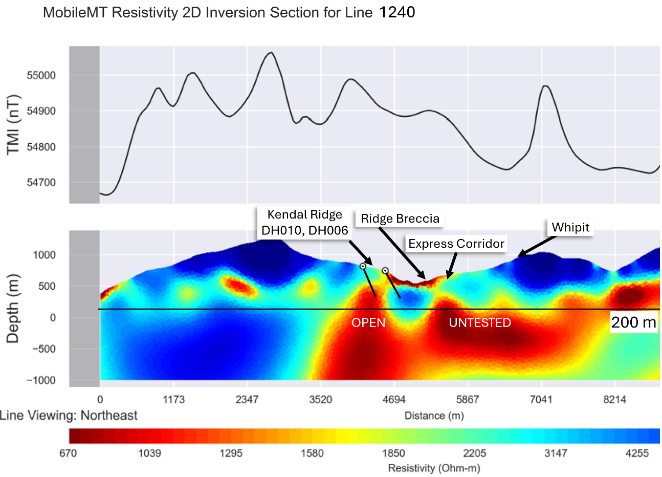
Express Corridor – This 1.3 km x 0.4 km north-trending zone is defined and underlain by a linear conductive feature (Figure 6) and the southern half is characterized at the surface by highly anomalous copper, molybdenum, gold, silver and bismuth that is coincident with low Th/K ratios and low magnetic response in the magnetic analytic signal. The southernmost part of this zone is underlain by the 27 Zone, an area initially identified by chalcocite-bearing samples with 27.5% copper in rock grab samples. This zone has highly anomalous bismuth and tungsten in soil.
The preliminary pXRF results from the expanded soil program provide additional support for these areas, with the highest copper and associated porphyry-indicator responses concentrated within and around the Express Corridor.
Neither target has been drill tested, providing significant opportunity for follow-up exploration.
Click Image To View Full Size
Figure 7: Ridge Breccia and Express Corridor target areas and corresponding cross-section of MMT high conductivity target at depth.
3DIP Survey
Red Canyon finalized a geophysical survey agreement with SJ Geophysics Ltd. to execute a comprehensive, high-resolution 3DIP survey at Kendal. Mobilization occurred mid-September 2026.
The primary objective of the 3DIP campaign is to generate unconstrained three-dimensional inversions of resistivity and chargeability across the project’s principal geochemical, magnetic and conductivity anomalies.
Unlike conventional two-dimensional IP surveys, the multi-line 3DIP configuration is designed to provide improved three-dimensional resolution and reduce distortions across lines, allowing the Company to better define complex and potentially deep-seated mineralization at Kendal.
The program utilizes SJ Geophysics’ proprietary Volterra Distributed Acquisition System to gather deep-penetrating subsurface geophysical data across the principal target areas. The survey features an advanced multi-line Diamond Array configuration, utilizing active receiver arrays of up to 2,000 m in length to collect full-waveform data both ahead of and behind each current injection point.
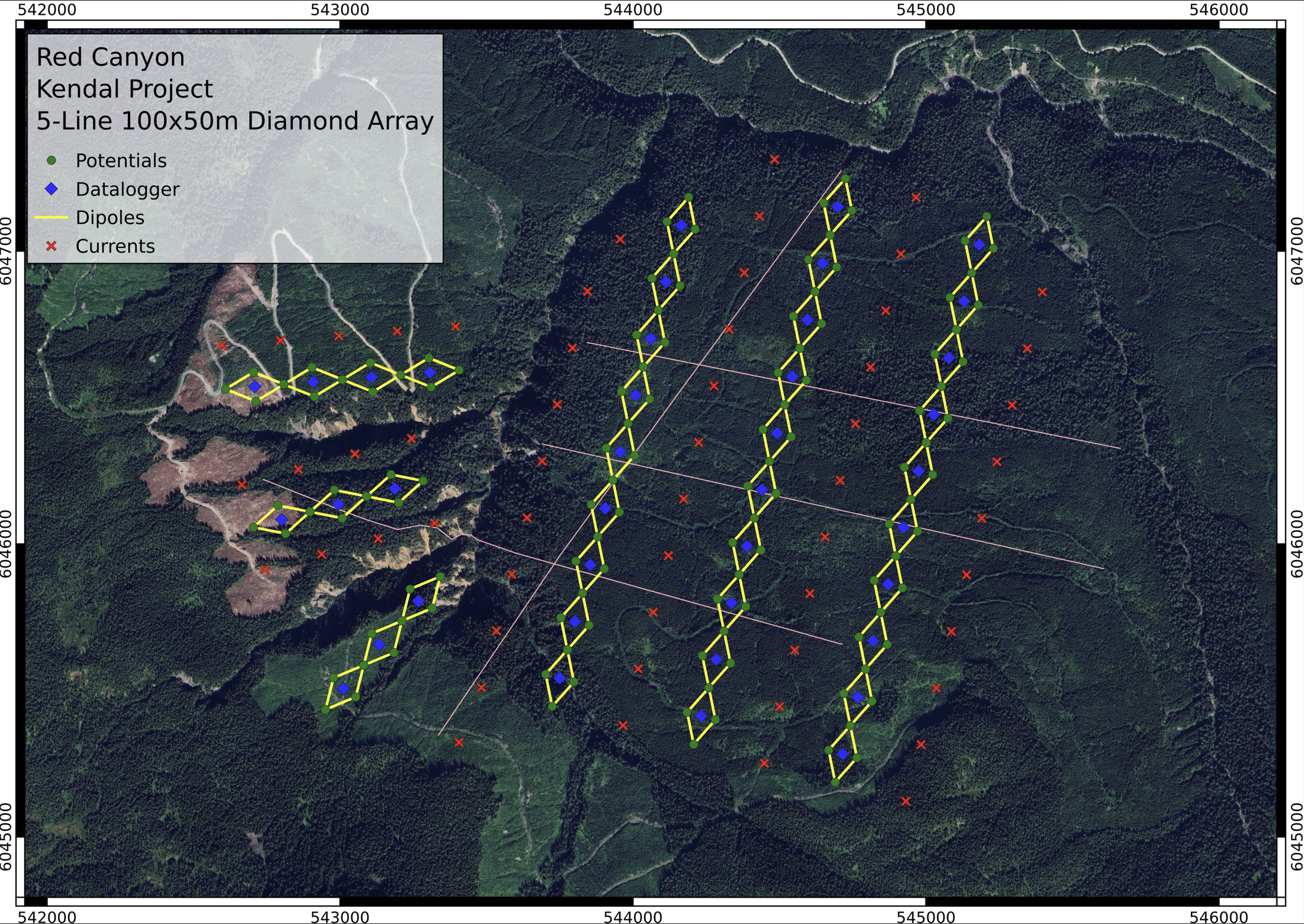
The custom-designed grid will span the main Kendal Creek drainage and comprise three north-northeast oriented lines spaced approximately 250 m apart on the east side of Kendal Creek, together with three east-to-northeast oriented lines positioned along ridges on the west side of Kendal Creek (Figure 8).
Current injections will occur at approximately 200 m intervals, with the flexibility to reduce spacing to 100 m over high-priority targets to maximize resolution.
The Company also intends to conduct a Magnetotelluric (“MT”) survey conducted concurrently during transmitter off-times. The MT survey would utilize high-sensitivity induction magnetometers to develop a complementary resistivity model extending to depths of approximately 1,500 m or more, potentially enhancing the Company’s ability to identify deeper targets beneath the known surface footprint.
Results with inversion modeling are expected in early Q4, 2026.
Click Image To View Full Size
Figure 8: Overview of the planned Kendal 3DIP survey grid, including proposed receiver lines, current injection locations and principal exploration target areas.
About Red Canyon Resources
Red Canyon Resources Ltd. (CSE: REDC) is a technically-driven, discovery-focused mineral exploration company exploring North America’s top copper jurisdictions. The Company’s core goal is to make impactful copper discoveries and has a portfolio of 100%-owned copper and copper-gold porphyry exploration projects.
The Company’s technical team consists of experienced geoscientists with diverse capital market, junior, and major mining company backgrounds and a track record of success.
For more information, please visit the Company's website at www.redcanyonresources.com.
Red Canyon is part of the NewQuest Capital group, a discovery-driven investment company that builds value through the incubation and financing of mineral projects and companies. Further information about NewQuest can be found on the company website at www.nqcapitalgroup.com.
1 Red Canyon has two projects subject to option earn in agreements whereby the Company can earn into 100% of the projects.
The Canadian Securities Exchange does not accept responsibility for the adequacy or accuracy of this press release.
Qualified Person:
The technical information contained in this update has been reviewed and approved by Wendell Zerb, P. Geol, a “Qualified Person” (“QP”) as defined in National Instrument 43-101 – Standards of Disclosure for Mineral Projects. Mr. Zerb is not independent by reason of being the Chairman, President and CEO of the Company.
FORWARD-LOOKING STATEMENTS
This news release includes certain forward-looking statements and forward-looking information (collectively, “forward-looking statements”) within the meaning of applicable Canadian securities legislation. All statements, other than statements of historical fact, included herein including, without limitation, statements regarding future capital expenditures, exploration activities and the specifications, targets, results, analyses, interpretations, benefits, costs and timing of them, and the anticipated business plans and timing of future activities of the Company, are forward-looking statements. Although the Company believes that such statements are reasonable, it can give no assurance that such expectations will prove to be correct. Often, but not always, forward looking information can be identified by words such as “pro forma”, “plans”, “expects”, “may”, “should”, “budget”, “scheduled”, “estimates”, “forecasts”, “intends”, “anticipates”, “believes”, “potential” or variations of such words including negative variations thereof, and phrases that refer to certain actions, events or results that may, could, would, might or will occur or be taken or achieved. Forward-looking statements involve known and unknown risks, uncertainties and other factors which may cause the actual results, performance or achievements of the Company to differ materially from any future results, performance or achievements expressed or implied by the forward-looking statements. Such risks and other factors include, among others, risks related to the anticipated business plans and timing of future activities of the Company, including the Company’s exploration plans and the proposed expenditures for exploration work thereon, the ability of the Company to obtain sufficient financing to fund its business activities and plans, the ability of the Company to obtain the required permits, changes in laws, regulations and policies affecting mining operations, the Company’s limited operating history, currency fluctuations, title disputes or claims, environmental issues and liabilities, as well as those factors discussed under the heading “Risk Factors” in the Company’s prospectus dated October 12, 2023 and other filings of the Company with the Canadian Securities Authorities, copies of which can be found under the Company’s profile on the SEDAR+ website at www.sedarplus.ca.
Readers are cautioned not to place undue reliance on forward-looking statements. The Company undertakes no obligation to update any of the forward-looking statements, except as otherwise required by law.
