Archive
Loyalist Completes Preliminary Review of the DeSantis Gold Property, Identifying Six New Drill Targets
 | |||||||||
Toronto, Ontario – TheNewswire – April 23, 2026 – Loyalist Exploration Limited (CSE:PNGC) (“Loyalist” or the “Company”) is pleased to announce the completion of a preliminary review of its DeSantis gold property (the “Property” or the “DeSantis Property”), located approximately 4.5 kilometres (“km”) southwest of Timmins, Ontario. Six priority targets have been identified, plus an additional target on the McEnaney claims to the east, highlighting the significant exploration potential of the Property.
In addition, Loyalist has identified a series of historical progress reports from 1963–1964 that reference the New Hope Porcupine (DeSantis) property and include historical tonnage estimates and sample results for that property prepared in support of a then-contemplated restart. Readers are cautioned that these historical estimates are not current, have not been verified by the Qualified Person, and should not be relied upon; see the Cautionary Statement under “Historical Documents Support Additional Ore Potential at DeSantis” below.6
DeSantis Preliminary Review Highlights:
-
Six priority targets identified in and around the historic DeSantis Mine workings
-
1963–1964 historical progress reports reference the New Hope Porcupine (DeSantis) property and include historical tonnage estimates (non-NI 43-101 compliant, not current, not verified and not to be relied upon — see Cautionary Statement below)
-
Shallow up-dip extension of the Albitite Zone (Target 1) from surface to the 800-foot level with the potential to add resources to the property
-
Possible parallel gold zone above the Albitite Zone (Target 4) includes a notable intersection of 25.0 g/t Au over 0.61 m
-
Depth extension of the Albitite Zone (Targets 3a 3b) highlighted as high-priority exploration target
-
West extension of the Hydrothermal Zone (Target 2) supported by historical drill intercepts
-
Notable historical intercepts include 7.54 g/t Au over 1.52 m (Target 6) and 3.26 g/t Au over 1.25 m (McEnaney claims)
-
Review based on 488 drill holes totalling 101,945.4 m and 21,158 gold assays
Errol Farr, Loyalist’s President & Chief Executive Officer commented, “6 significant targets and mineralization left in the historic workings make DeSantis a compelling exploration property with significant untapped potential along the prime Destor-Porcupine corridor. The next step is to conduct a more detailed review and mapping of the historic workings and creation of a summer work program. We look forward to advancing these targets as part of our broader Buy Timmins, Mine Timmins strategy.”
DeSantis Project Overview
The Property is located approximately 4.5 km southwest of Timmins, Ontario and is situated 11 km west of Discovery Silver’s Dome Mine, and 14 km east of Pan American Silver’s Timmins Mine. It covers nearly 5 km of strike length along the north side of the Destor-Porcupine Deformation Zone (DPDZ), a major structure controlling gold deposits in the region. Between 1926 and 1943, the DeSantis Mine produced 35,784 oz. of gold, 3,142 oz. of silver and 193 lb. of scheelite from 196,928 tons of material at an average mill head grade of 0.19 oz/ton Au1.
A historical non-NI 43-101 compliant resource estimate totalling 182,505 tonnes at 8.64 g/t Au2,3,4,5 was completed across the Albitite and Hydrothermal Zones. Investors are cautioned not to rely on this historical estimate as a current mineral resource; a qualified person has not done sufficient work to classify it as current under NI 43-101 standards.
Click Image To View Full Size
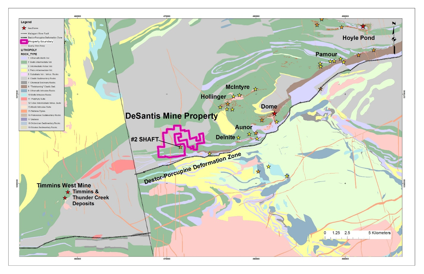
Figure 1. The DeSantis Property boundary (magenta) is shown with a bedrock geology map of the Timmins-Porcupine mining district and the locations of head frames (red stars), historical shafts (orange stars), and gold occurrences (yellow stars) across the region (modified from the Excellon Resources Inc. news release dated October 31, 2012).
Preliminary Review – Data Overview
An initial review of a historical database acquired by the Company included the following data:
-
488 drill holes totalling 101,945.4 m (surface and underground), with hole depths ranging from 5.4 m to 1,354 m
-
21,158 gold assays from core samples
-
Wireframes of historical underground mine workings
-
Wireframes of the Hydrothermal and Albitite Zones
Two main gold-mineralized domains have been historically recognized at the DeSantis Mine and described as follows:
Albitite Zone (AZ): This altered and gold-mineralized zone sits in close proximity to a sheared mafic/ultramafic contact, approximately 260 m south of Shaft No. 2. The zone exhibits a northeasterly strike with an apparent southerly dip.
Hydrothermal Zone (HZ): Spatially associated with a zone of hydrothermal alteration in the mafic volcanics, primarily located west of the shaft. The zone strikes west-southwesterly and dips -40° to -50° southward. Gold values are genetically associated with relatively sparse and irregular quartz-carbonate stringers, minor tourmaline, and up to 5% pyrite.
Targets and Areas of Interest
The preliminary review identified six priority targets in and around the DeSantis Mine, plus an additional target on the McEnaney claims to the east.
Click Image To View Full Size
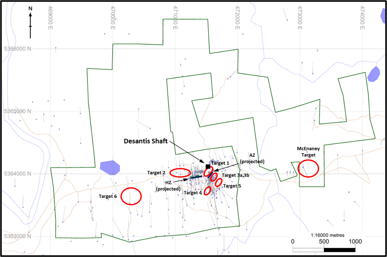
Figure 2: Plan map of the Desantis property showing the location of targets (projected to surface) identified in the preliminary data review.
Click Image To View Full Size
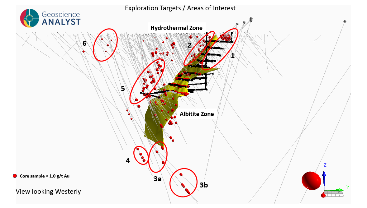
Figure 2. A 3d view looking towards the west, showing the target areas proximal to the DeSantis Mine workings.
All drill intercepts referenced below are historical, have been sourced from a database acquired by the Company, and have not been independently verified by the Qualified Person. Reported widths are downhole (core-length) intervals; true widths are not known at this stage of review. Investors are cautioned not to rely on these historical data as current. Drill hole collar information for each historical hole referenced below is summarized in Table 1 near the end of this news release.
Target 1 – Shallow Up-Dip Extension of the Albitite Zone
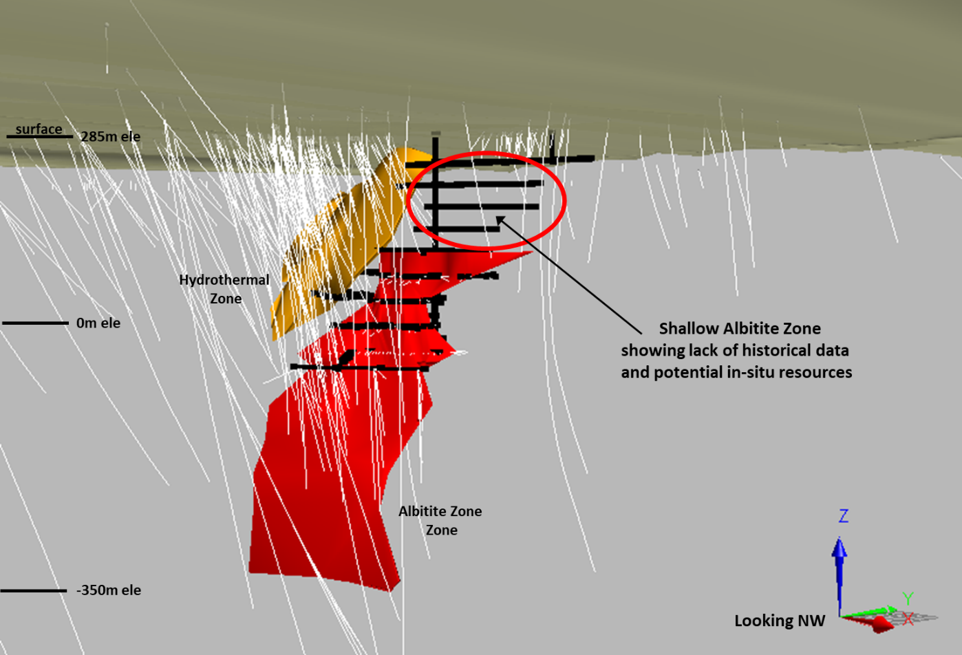
Target 1 is a high priority target that covers the shallow up-dip extension of the Albitite Zone from surface to the 800-foot level. There are no documented drill holes or underground sample results from this area in the recently reviewed database. This lack of information is most likely due to data loss over time, as the underground workings clearly intersect this target area in the past. Loyalist recommends a thorough data search to identify any missing historical records. If unsuccessful, a small drilling program is recommended to evaluate its gold potential in these upper levels of the historical underground workings.
Click Image To View Full Size
Figure 3. 3D image showing the Target 1 area from surface to the 800-foot level where historical information is lacking.
Target 2 – Shallow West Extension of the Hydrothermal Zone:
Historical drilling west of the Hydrothermal Zone intersected gold values in altered mafic volcanics including the following:
|
Hole ID |
From (m) |
To (m) |
Length (m) |
Grade (g/t Au) |
|
DS13-007 |
37.25 |
40.35 |
3.10 |
2.68 |
|
MJD85-006 |
130.00 |
131.22 |
1.22 |
4.47 |
|
MJD85-007 |
93.57 |
94.09 |
0.52 |
2.26 |
|
H61-026 |
65.41 |
65.87 |
0.46 |
1.37 |
|
H61-026 |
71.45 |
71.93 |
0.48 |
4.45 |
|
H61-026 |
79.25 |
79.86 |
0.61 |
1.71 |
|
H61-030 |
30.78 |
31.79 |
1.01 |
1.03 |
|
H61-030 |
53.46 |
54.44 |
0.98 |
1.71 |
Additional work is recommended to determine if these intersections represent the extension of the HZ.
Targets 3a & 3b – Depth Extension of the Albitite Zone:
Historic deep drilling on the Albitite zone intersected the following significant gold values highlighting the potential for the continuation of the AZ at depth:
|
Hole ID |
From (m) |
To (m) |
Length (m) |
Grade (g/t Au) |
|
DS12-004 |
845.00 |
848.00 |
3.00 |
5.34 |
|
DS11-016F |
1,192.45 |
1,218.40 |
25.95 |
2.29 |
|
Including |
1,196.30 |
1,199.65 |
3.35 |
6.48 |
|
Including |
1,210.20 |
1,211.65 |
1.45 |
10.00 |
|
DS11-016B |
1,213.25 |
1,215.35 |
2.10 |
3.19 |
Target 4 – Possible Parallel Zone Above the Albitite Zone
While testing the Albitite Zone, several historical drill holes intersected narrow gold values that appear to define a possible zone parallel to and sitting above the AZ. Notable intersections include:
|
Hole ID |
From (m) |
To (m) |
Length (m) |
Grade (g/t Au) |
|
DS10-002 |
290.02 |
290.63 |
0.61 |
25.00 |
|
MJD85-012 |
287.12 |
295.02 |
7.90 |
1.74 |
|
Including |
292.43 |
292.88 |
0.45 |
12.75 |
Additional data compilation is recommended, potentially leading to a drill program to test the continuity and grade of the target.
Target 5 – Deep Isolated Anomaly (DS12-003A)
A low-priority deep target identified by drill hole DS12-003A, which intersected anomalous gold mineralization south of the Hydrothermal and Albitite Zones. Testing of this target may be incorporated into a future deep drilling program targeting the Albitite Zone depth extension (Targets 3a and 3b). Assay highlights are shown below:
|
Hole ID |
From (m) |
To (m) |
Length (m) |
Grade (g/t Au) |
|
DS12-003A |
740.00 |
741.50 |
1.50 |
1.30 |
|
DS12-003A |
766.20 |
767.00 |
0.80 |
1.66 |
|
DS12-003A |
787.70 |
788.54 |
0.84 |
2.48 |
Target 6 – West Property Target:
A low-priority target following up on anomalous gold values intersected in historical drill holes on the western end of the property. Drill hole S34-008 returned a significant intercept near the bottom of the hole, warranting further follow-up exploration:
|
Hole ID |
From (m) |
To (m) |
Length (m) |
Grade (g/t Au) |
|
S34-008 |
304.80 |
306.32 |
1.52 |
7.54 |
McEnaney Claims Target (East Property)
An additional low-priority target occurs on the McEnaney claims to the east of the DeSantis mine area. Widely-spaced historical drill holes intersected anomalous gold values in altered mafic volcanics, providing a basis for follow-up exploration. Notable intercepts are shown below:
|
Hole ID |
From (m) |
To (m) |
Length (m) |
Grade (g/t Au) |
|
DS13-011 |
163.75 |
165.00 |
1.25 |
3.26 |
Historical Documents Support Additional Ore Potential at DeSantis
In conjunction with the preliminary review, Loyalist has identified a set of historical progress reports, filed under Timmins File T-140 with the Ontario Ministry of Mines and dated 1963–1964, that reference the DeSantis Mine (then known as New Hope Porcupine Mines Ltd.). The reports were authored by Grant and Oja Limited (Mine & Exploration Management) on behalf of Kenilworth Mines Limited. During this period, Kenilworth Mines Limited operated two separate properties: its own Kenilworth Mine and, under a 99-year operational contract dated August 1963, the adjacent New Hope Porcupine (DeSantis) Mine, located approximately 2.25 miles northwest of the Kenilworth workings. Only the portions of the T-140 reports that describe the New Hope Porcupine (DeSantis) property are relevant to the current DeSantis Property; information relating to the separate Kenilworth Mine is not disclosed here.
The T-140 reports include a section specifically addressing the New Hope Porcupine (DeSantis) property. The tonnage figures reported for the New Hope Porcupine property are attributed in the November 16, 1963 report to W.R. Dunbar, who served as consulting geologist to the DeSantis Mine during its earlier period of operation. Key figures from these documents relating to the New Hope Porcupine (DeSantis) property include:
-
833-20 stope area, 800-foot level (historical estimate): Approximately 108,000 tons of potential material indicated by drilling (stope 833-20 plus diamond drill holes 15, 19 and 23), reported at a grade of 0.40 oz/ton Au uncut, as estimated by W.R. Dunbar and cited in the November 16, 1963 report.
-
950-foot level (historical estimate): Approximately 157,000 tons of potential material indicated by four additional drill holes (holes 25, 36, 28 and 37) at the 950-foot level, reported at a grade of 0.40 oz/ton Au uncut.
-
West of the diabase dike (historical estimate): Approximately 265,000 tons reported at a grade of 0.40 oz/ton Au uncut, located west of a prominent diabase dike on the New Hope Porcupine property.
-
Aggregate above the 1,200-foot level (historical estimate): W.R. Dunbar estimated, in total, approximately 700,000 tons above the 1,200-foot level on the New Hope Porcupine property, as cited in the November 16, 1963 report. No grade was disclosed in that report for the aggregate figure beyond the 0.40 oz/ton Au uncut grade reported for the component 108,000-ton, 157,000-ton and 265,000-ton estimates described above.
The August 27, 1963 shareholder progress report states that the DeSantis Mine was closed during wartime due to a shortage of available labour and sharply rising material costs, rather than a lack of ore, and that following closure its equipment was progressively repossessed or sold. The property was subsequently reorganized under the name New Hope Porcupine Mines, Ltd. in the late 1950s, with additional surface diamond drilling reported in 1953. Readers should note that the August 27, 1963 document is a promotional circular issued by Kenilworth Mines Limited to its shareholders, the tonnage and grade figures attributed to W.R. Dunbar have not been independently verified by the Qualified Person, and the characterization of the reasons for closure reflects the views of the author of that circular.
Cautionary Statement Regarding the 1963–1964 Historical Estimates.
The historical tonnage and grade figures disclosed above in respect of the New Hope Porcupine (DeSantis) property are taken from Progress Reports authored by Grant and Oja Limited (Mine & Exploration Management) on behalf of Kenilworth Mines Limited, dated July 8, 1963, August 27, 1963, November 16, 1963 and January 28, 1964, and filed under Timmins File T-140 with the Ontario Ministry of Mines. The tonnage estimates are attributed in those reports to W.R. Dunbar.
The 1963–1964 reports predate both NI 43-101 and CIM Definition Standards and use the historical categories “proven,” “probable,” “possible” and “indicated” as those terms were understood at the time; these categories are not the same as, and are not directly comparable to, the CIM mineral resource and mineral reserve categories (Measured, Indicated, Inferred, Probable and Proven) referenced in NI 43-101. The historical estimates were prepared to support an exploration and financing program and the key assumptions, parameters, cut-off grades, drilling density, sampling methodology, QA/QC procedures and mining parameters underlying the estimates are not described in the T-140 reports and are not available to the Company. As a result, the Company considers the historical estimates to be of limited reliability, although potentially relevant as an exploration guide to areas where further work may be warranted. In order for the historical estimates to be upgraded or verified as current mineral resources under NI 43-101, a qualified person would be required to locate and review the underlying drill logs, assay certificates, sampling data and survey information (to the extent these records still exist), undertake a program of twinned drilling, re-sampling and independent check assaying, apply current CIM classification criteria, and prepare a current mineral resource estimate supported by a technical report.
A Qualified Person has not done sufficient work to classify the 1963–1964 historical estimates as current mineral resources or mineral reserves. The Company is not treating the 1963–1964 historical estimates as current mineral resources or mineral reserves. The historical estimates should not be relied upon. It is uncertain whether, following further evaluation and exploration, any of the historical estimates will ever be able to be reported as current mineral resources or mineral reserves in accordance with NI 43-101.
Subject to the cautionary statement above, Loyalist views the 1963–1964 T-140 reports as providing useful additional historical context for the exploration potential of the New Hope Porcupine (DeSantis) property. The depth extension of the Albitite Zone (Targets 3a & 3b), the shallow up-dip gap (Target 1), and the possible parallel zone above the Albitite Zone (Target 4) identified in the current preliminary review cover portions of the property that, based on the T-140 reports, had not been fully tested at the time the DeSantis Mine ceased operations. The Company intends to consider the historical information, together with the modern drill hole database, as part of its planned detailed review and summer work program for the Property.
Summary of Historical Drill Holes Referenced in this News Release
Collar coordinates, orientation, and total length for the historical drill holes referenced in the target descriptions above are summarized in Table 1.
Table 1. Summary of Historical Drill Holes Referenced in this News Release
|
Hole ID |
Easting (m) |
Northing (m) |
Elev. (m) |
Azi. (°) |
Dip (°) |
Length (m) |
Associated Target |
|
DS10-002 |
471,619.3 |
5,363,688.2 |
276.1 |
323 |
-77 |
544.4 |
Target 4 |
|
DS11-016B |
471,675.0 |
5,363,370.0 |
285.0 |
345 |
-67 |
1,354.0 |
Targets 3a & 3b |
|
DS11-016F |
471,675.0 |
5,363,370.0 |
285.0 |
345 |
-67 |
1,342.0 |
Targets 3a & 3b |
|
DS12-003A |
471,860.0 |
5,363,465.0 |
285.0 |
330 |
-75 |
932.0 |
Target 5 |
|
DS12-004 |
471,917.0 |
5,363,603.0 |
285.0 |
306 |
-70 |
1,088.0 |
Targets 3a & 3b |
|
DS13-007 |
471,071.0 |
5,364,127.0 |
285.0 |
360 |
-45 |
252.0 |
Target 2 |
|
DS13-011 |
473,046.0 |
5,364,106.0 |
285.0 |
155 |
-65 |
408.0 |
McEnaney Claims |
|
H61-026 |
471,150.3 |
5,364,059.0 |
285.0 |
351 |
-47 |
122.5 |
Target 2 |
|
H61-030 |
471,136.3 |
5,364,130.0 |
285.0 |
351 |
-48 |
97.8 |
Target 2 |
|
MJD85-006 |
471,087.0 |
5,363,991.0 |
285.0 |
000 |
-45 |
227.7 |
Target 2 |
|
MJD85-007 |
471,025.0 |
5,364,017.0 |
283.0 |
000 |
-45 |
285.6 |
Target 2 |
|
MJD85-012 |
471,618.1 |
5,363,689.7 |
276.2 |
322 |
-80.8 |
660.5 |
Target 4 |
|
S34-008 |
470,462.0 |
5,363,322.0 |
285.0 |
008 |
-45 |
323.7 |
Target 6 |
Notes: (1) Collar coordinates are reported in UTM NAD83 Zone 17N; elevations are in metres above sea level. (2) Azimuths are reported relative to true north; azimuth and dip values represent the collar (start-of-hole) orientation recorded in the downhole survey database and do not reflect downhole deviation. (3) Length is the total drilled depth recorded in the historical database. (4) All drill holes listed are historical, were completed by prior operators of the DeSantis Property between 1961 and 2013, and are sourced from a historical database acquired by the Company. A Qualified Person has not independently verified the collar, survey, or assay data; investors are cautioned not to rely on these historical data as current. (5) Holes prefixed “MJD85-” and “H61-” are historical underground holes with collars surveyed underground; original historical collar elevations have been retained where available. (6) Reported intercepts in the target descriptions above are downhole (core-length) intervals; true widths are not known.
Statement Regarding Historical Mineral Resource Estimates
The historical Mineral Resource Estimate (“MRE”) on the DeSantis Property is unclassified and does not comply with CIM Definition Standards on Mineral Resources and Mineral Reserves as required by NI 43-101. The MRE was taken from a report titled “TECHNICAL REPORT on the DESANTIS PROPERTY Porcupine Mining Division Ogden Township, Ontario, Canada” authored by Minorex Consulting Ltd. and dated May 30, 2011. Investors are cautioned not to treat the estimate as current or rely on the estimate in making an investment decision. The MRE is being included herein to provide shareholders with background on the rationale for acquiring the asset. A qualified person has not done sufficient work to classify this historical MRE as current mineral resources, and the Company is not treating this historical MRE as a current estimate. It is uncertain whether following evaluation and/or further exploration, the historical MRE will ever be able to be reported in accordance with NI 43-101. The Company has no current plans to undertake the work to bring the MRE up to the CIM reporting standards.
1 TECHNICAL REPORT on the DESANTIS PROPERTY Porcupine Mining Division Ogden Township, Ontario, Canada for Lateegra Gold Corp., May 30, 2011, page 13
2 TECHNICAL REPORT on the DESANTIS PROPERTY Porcupine Mining Division Ogden Township, Ontario, Canada for Lateegra Gold Corp., May 30, 2011, page 14
3TECHNICAL REPORT on the DESANTIS PROPERTY Porcupine Mining Division Ogden Township, Ontario, Canada for Lateegra Gold Corp., May 30, 2011, page 41
4 Assumptions for the generation of the Albitite and Hydrothermal zone historical resources are not available to the company.
5 A review of the historical database along with confirmation drilling would be required to upgrade/verify the historical resource estimates.
6 Progress Reports authored by Grant and Oja Limited (Mine & Exploration Management), prepared for the Directors and Shareholders of Kenilworth Mines Limited, Timmins, Ontario, dated July 8, 1963, August 27, 1963, November 16, 1963 and January 28, 1964. Filed under Timmins File T-140, Ontario Ministry of Mines. Only information in those reports relating to the New Hope Porcupine (DeSantis) property is referenced in this news release.
Qualified Person
Curtis Ferron, P.Geo. (ON), principal geology consultant for Loyalist and a “Qualified Person” as defined by NI 43-101, has reviewed and approved the technical content of this press release.
Neither the Canadian Securities Exchange nor its Market Regulator (as that term is defined in the policies of the Canadian Securities Exchange) have reviewed or accept responsibility for the adequacy or accuracy of this release.
About Loyalist Exploration Limited
Loyalist Exploration Limited is a mineral exploration company concentrating on acquiring, exploring, and developing quality mineral properties in Canada. The Company is currently focused on its “Buy Timmins” strategy, with the recent acquisitions of the Tully gold property, the Loveland nickel/copper/gold property, the Gold Rush gold/silver property, and the DeSantis gold property, all located in the Timmins, Ontario mining district.
For further information please visit the Company’s website at www.loyalistexploration.com or contact:
Loyalist Exploration Limited
Errol Farr, President and CEO
Email: efarr@loyalistexploration.com
Tel: 647-296-1270
This news release includes certain “forward-looking statements” which are not comprised of historical facts. Forward-looking statements include estimates and statements that describe the Company’s future plans, objectives or goals, including words to the effect that the Company or management expects a stated condition or result to occur. Forward-looking statements may be identified by such terms as “believes”, “anticipates”, “expects”, “estimates”, “may”, “could”, “would”, “will”, or “plan”. Since forward-looking statements are based on assumptions and address future events and conditions, by their very nature they involve inherent risks and uncertainties. Although these statements are based on information currently available to the Company, the Company provides no assurance that actual results will meet management’s expectations. Risks, uncertainties, and other factors involved with forward-looking information could cause actual events, results, performance, prospects, and opportunities to differ materially from those expressed or implied by such forward-looking information. Forward looking information in this news release includes, but is not limited to, the Company’s objectives, goals or future plans, statements, exploration results, potential mineralization, the estimation of mineral resources, exploration and mine development plans, timing of the commencement of operations and estimates of market conditions. Factors that could cause actual results to differ materially from such forward-looking information include, but are not limited to, failure to identify mineral resources, failure to convert estimated mineral resources to reserves, delays in obtaining or failures to obtain required governmental, environmental or other project approvals, political risks, inability to fulfill the duty to accommodate First Nations and other indigenous peoples, uncertainties relating to the availability and costs of financing needed in the future, changes in equity markets, inflation, changes in exchange rates, fluctuations in commodity prices, delays in the development of projects, capital and operating costs varying significantly from estimates and the other risks involved in the mineral exploration and development industry, capital market conditions, restriction on labour and international travel and supply chains, and those risks set out in the Company’s public documents filed on SEDAR+. Although the Company believes that the assumptions and factors used in preparing the forward-looking information in this news release are reasonable, undue reliance should not be placed on such information, which only applies as of the date of this news release, and no assurance can be given that such events will occur in the disclosed time frames or at all. The Company disclaims any intention or obligation to update or revise any forward-looking information, whether as a result of new information, future events or otherwise, other than as required by law.