Archive
VR confirms kimberlite diatreme breccia in Hole 002 at the center of the large, 1.2 km magnetic anomaly at Northway in northern Ontario
 | |||||||||
May 18, 2023 – TheNewswire - Vancouver, B.C.: VR Resources Ltd. (TSXV:VRR), (FSE:5VR); (OTC:VRRCF), the "Company", or “VR”, is pleased to announce that drilling has successfully intersected kimberlite diatreme breccia in Hole NW23-002 located in the center of the large magnetic anomaly, 1.2 km in diameter, at its Northway project located in northern Ontario.
Hole NW23-002 is 450 metres northwest of hole 001 located on the southern edge of the anomaly, thus confirming the presence of a very large kimberlite diatreme breccia pipe complex at Northway.
-
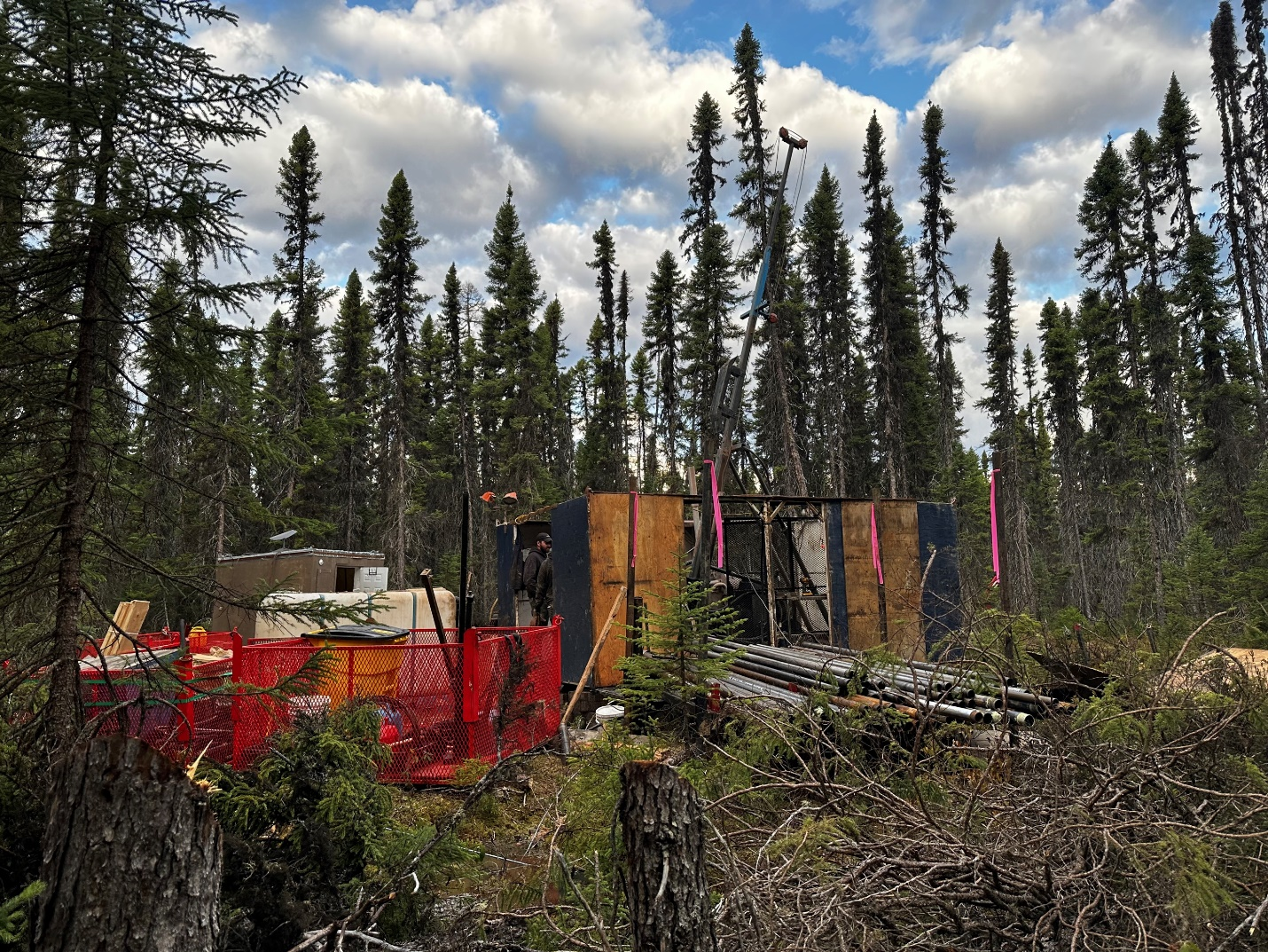
Figure 1. A photo of the drill at Northway, on the pad for NW23-002;
-
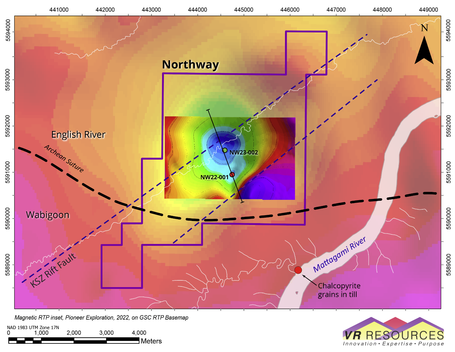
Figure 2. Magnetic map showing drill hole NW23-002 collared in the center of the magnetic anomaly at Northway which measures from 950 to 1,200 m across;
-
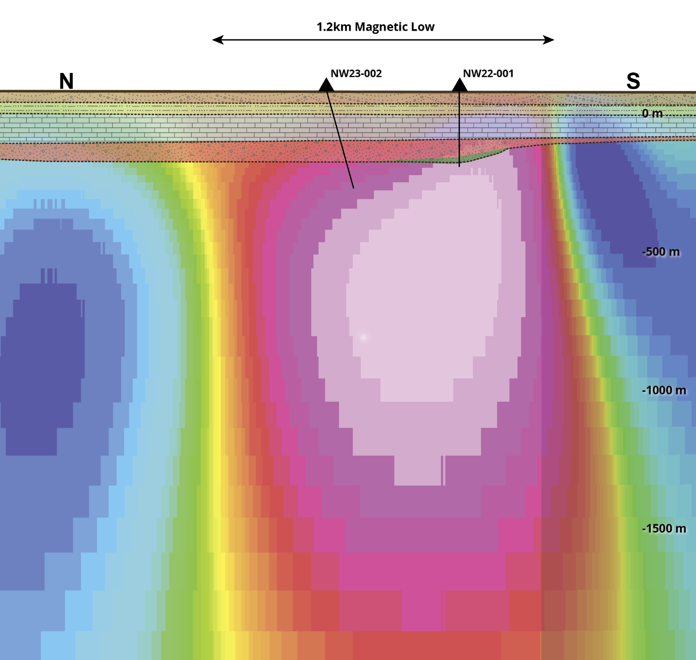
Figure 3. Cross-section view of 3D voxel model for a MVI magnetic inversion, showing vertical boundary conditions for the 1.2 km magnetic anomaly at Northway;
-
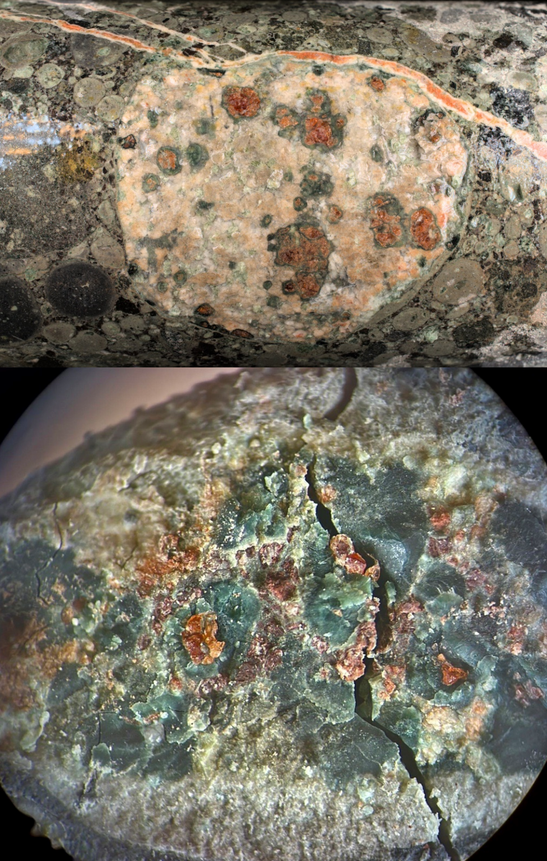
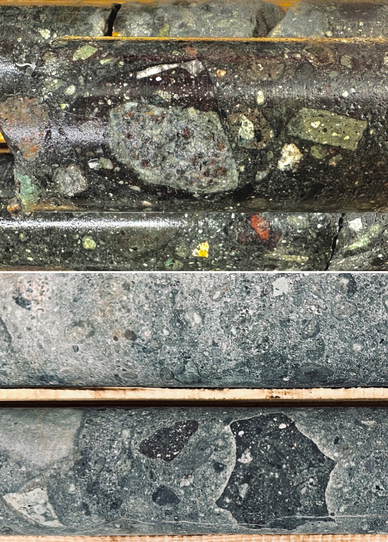
Figure 4. Drill core photos of garnet-bearing eclogite xenoliths within kimberlite breccia facies (XPK rock) in both holes 001 and 002 located 450 m apart within the magnetic anomaly.
-
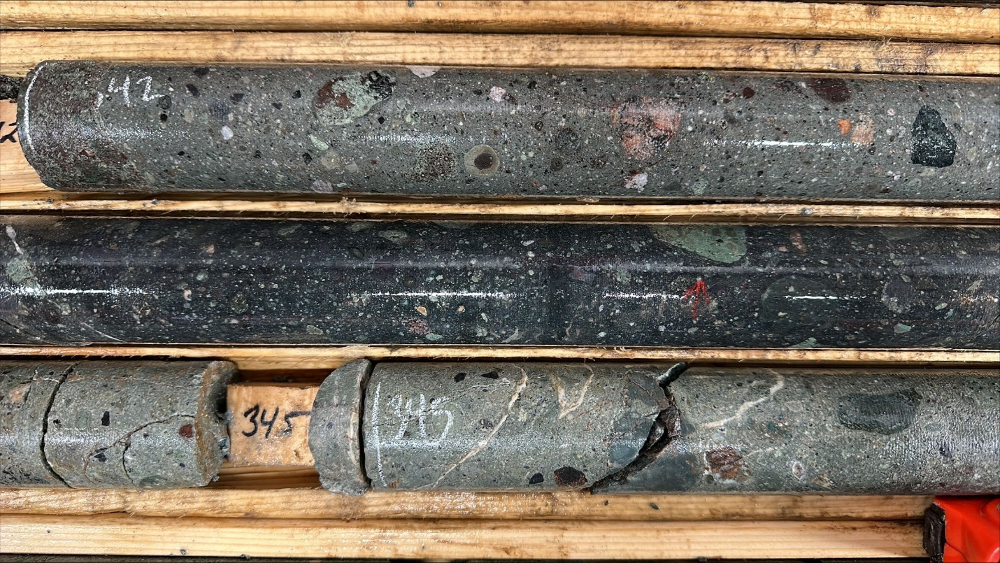
Figure 5. Drill core photos from hole 002 of tuffisitic kimberlite breccia facies - XPK rock;
-
Figure 6. Drill core photos from hole 002 of XPK facies, including olivine, clinopyroxene, and garnet-bearing xenoliths with accretionary magma crust and magmaclasts.
The top of the kimberlite breccia at Northway is preserved in both holes at the same vertical depth of 240m, at the base of the sedimentary cover of early Devonian sandstone and overlying limestone.
Hole 002 ended at 357 metres. The hole was terminated due to excessive caving within the hole at the stratigraphic unconformity at the top of the kimberlite.
Overall, lower curst and mantle-derived xenoliths, phlogopite and olivine megacrysts, and spherulitic magmaclasts increase in abundance downwards in hole 002, including kelyphite rimmed garnet-bearing eclogite at 330.8 m near the bottom of the hole. The MVI model in Figure 3 demonstrates the potential vertical extent of the kimberlite breccia intersected to date in both drill holes.
From VR’s CEO, Dr. Michael Gunning, “Well, Hole 2 just showed us that the Northway anomaly is real. It’s game on now for the potential of this large kimberlite complex, and the field of targets we have staked.
Intersecting kimberlite breccia in hole 002 below the same cover of limestone and sandstone as in hole 001 located some 450 m to the southeast confirms the discovery of an unusually large kimberlite diatreme breccia pipe complex at Northway. The uppermost crater facies are preserved in hole 001, and the modelling of our geophysical data only reinforces the vertical fabrics and textures we see in drill core, emphasizing the potential for the vertical extent of the diatreme breccia as implied in the MVI model in Figure 3, and the sheer volume potential for the overall breccia pipe complex at Northway.
We now have a successful test of the center of the large magnetic anomaly at Northway, and we have more than sufficient drill core to submit for a preliminary micro-diamond evaluation and compositional characterization of the various kimberlite breccia facies despite the termination of the hole early. The drill core from hole 002 has already been transported off-site for detailed logging, where it will be processed, prepared, and shipped to the SRC laboratory facility in Saskatoon for analysis. We will eagerly anticipate results by the end of the summer.
I would encourage our shareholders to remind themselves of the geological context for this discovery as outlined in the previous news release dated February 22, 2023, and as summarized on the Northway project page on the Company’s website at www.vrr.ca in order to appreciate the upside potential of Northway itself, and the expanded strategy related to the field of similar targets staked by VR.
We intend to stick to the discipline of the overall framework of an integrated program and budget for Northway and Hecla-Kilmer planned for this month. As we process the Northway core, the drill is on its way to Hecla-Kilmer, where we have two specific goals for this program:
-
Test two new areas for REE critical metal mineralization using new 3D inversion models from the recently obtained, ultra – high resolution drone magnetic data and reprocessed gravity data, and;
-
Obtain dedicated drill core for a metallurgy and beneficiation study at SGS Lakefield in Ontario.
The current Northway – H-K drill program is again being run from our road-accessible exploration camp located on HWY 634 at Otter Rapids, an Ontario hydro-electric facility (see photograph at ww.vrr.ca).
Technical Information
Summary technical and geological information for the Company’s various exploration properties is available at the Company’s website at www.vrr.ca.
Technical information for this news release has been prepared in accordance with the Canadian regulatory requirements set out in National Instrument 43-101. Justin Daley, P.Geo., VP Exploration and a non-independent Qualified Person oversees and/or participates in all aspects of the Company’s mineral exploration projects, and the content of this news release has been reviewed on behalf of the Company by the CEO, Dr. Michael Gunning, P.Geo., a non-independent Qualified Person.
About the Northway Property and Project
The Northway property is located in northern Ontario. It is approximately 12 km northeast of the Company’s REE critical metal discovery at its Hecla-Kilmer project. The nearest town is Moosonee located on tidewater at James Bay some 125 kilometres to the northeast. Kapuskasing is located about the same distance to the southwest, on the Trans-Canada Highway (Provincial HWY 11).
Exploration is based out of a camp at the hydroelectric facility at Otter Rapids located about 50 km to the southeast of Northway. Provincial Highway 634 provides road access to Otter Rapids from Smooth Rock Falls, located at the junction of HWY 634 with the Trans-Canada Highway. The property itself is just 15 km west of the Ontario Northern railway (ONR) which provides service to the communities on James Bay.
The Northway property consists of 64 contiguous claims in a single, 4 x 7 km block 1,315 ha in size. It was expanded to a district-scale project by staking directly 284 new claims in 19 additional properties covering magnetic anomalies near Northway and proximal to the ONR line, within an area of 50 x 70 km overall.
The properties are owned 100% by VR. There are no underlying payments or interests on the property and no royalty interests because the property was staked by VR directly.
Northway is located on provincial crown land in northern Ontario, with mineral rights administered by the Ontario Ministry of Northern Development, Mines, Natural Resources and Forestry (“MNDM”). There are no annual payments, but the MNDM requires certain annual exploration expenditures and reporting. The property falls within the traditional territories of the Moose Cree and Taykwa Tagamou First Nations.
About VR Resources
VR is an established junior exploration company focused on greenfields opportunities in copper, gold and critical metals (TSX.V: VRR; Frankfurt: 5VR; OTCQB: VRRCF). VR is the continuance of 4 years of active exploration in Nevada by a Vancouver-based private company. The foundation of VR is the diverse experience and proven track record of its Board in early-stage exploration, discovery and M&A. The Company focuses on underexplored, large-footprint mineral systems in the western United States and Canada, and is well-financed for its mineral exploration and corporate obligations. VR owns its properties outright and evaluates new opportunities on an ongoing basis, whether by staking or acquisition.
ON BEHALF OF THE BOARD OF DIRECTORS:
“Michael H. Gunning”
____________________________
Dr. Michael H. Gunning, PhD, PGeo
President & CEO
For general information please use the following:
Website: www.vrr.ca
Email: info@vrr.ca
Phone: 604-262-1104
Forward Looking Statements
This press release contains forward-looking statements. Forward-looking statements are typically identified by words such as: believe, expect, anticipate, intend, estimate, postulate and similar expressions or those which, by their nature, refer to future events. Forward looking statements in this release include those related to the companies upcoming plans, such as “The drill program is expected to take a month to complete”, and “VR evaluates new opportunities on an ongoing basis, whether by staking or acquisition.”
This news release may contain statements and/or information with respect to mineral properties and/or deposits which are adjacent to and/or potentially similar to the Company’s mineral properties, but which the Company has no interest in nor rights to explore. Readers are cautioned that mineral deposits on similar properties are not necessarily indicative of mineral deposits on the Company’s properties.
Although the Company believes that the use of such statements is reasonable, there can be no assurance that such statements will prove to be accurate, and actual results and future events could differ materially from those anticipated in such statements. The Company cautions investors that any forward-looking statements by the Company are not guarantees of future performance, and that actual results may differ materially from those in forward-looking statements. Trading in the securities of the Company should be considered highly speculative. All of the Company’s public disclosure filings may be accessed via www.sedar.com and readers are urged to review these materials.
Neither the TSX Venture Exchange nor its Regulation Services Provider (as that term is defined in Policies of the TSX Venture Exchange) accepts responsibility for the adequacy or accuracy of this release.
Click Image To View Full Size
Figure 1. Drill rig set up on the pad for hole NW23-002 at the Northway project in northern Ontario; May, 2023.
Click Image To View Full Size
Figure 2. Drill hole locations on the large RTP magnetic low anomaly 900 – 1,200 m across at Northway, as derived from the ultra- high-resolution drone magnetic survey completed by VR in 2022, and plotted on the RTP magnetic base map for the region. Drill holes 001 and 002 are approximately 450 m apart. The solid black line refers to the cross-section view of the MVI magnetic model shown in Figure 3.
Also shown are faults related to the crustal-scale Kapuskasing Structural Zone (KSZ), a failed Proterozoic rift, and the Archean tectonic suture on the northern boundary of the Wabigoon sub-province of the northern Superior craton.
Click Image To View Full Size
Figure 3. Cross section view of the block model for vertical magnetic amplitude vector of the 3D MVI inversion of the ultra - high resolution drone magnetic data shown in plan map in Figure 2. The pink anomaly with sub-vertical boundary conditions corresponds to the RTP magnetic low in Figure 2, and it approximates the kimberlite diatreme breccia complex intersected in both drill holes, NW22-001 and NW23-002.
Photographs of garnet-bearing eclogite xenoliths within kimberlite diatreme breccia (XPK) in both drill holes are shown in Figure 4.
Click Image To View Full Size
Figure 4. Photographs of garnet-opx eclogite xenoliths with kelyphite rims in XPK kimberlite diatreme breccia facies in drill holes NW22-001 (upper photo; scale: 6cm) and NW22-002 (lower photo; scale: 2cm). The drill holes span 450 m of the 1.2 km magnetic anomaly, as shown on the plan map in Figure 2 and in the cross-section in Figure 3.
Click Image To View Full Size
Figure 5. Drill core photos of the kimberlite diatreme breccia intersected in drill hole NW23-002. Upper photo: garnet-bearing peridotite xenolith in autolith of kimberlite breccia within a kimberlite diatreme breccia phase with packed accretionary magmaclasts. Lower photo: cuspate thermal boundaries on kimberlite breccia autolith within a kimberlite diatreme breccia phase with spherulitic lapilli.
Click Image To View Full Size
Figure 6. Drill core photos of the XPK kimberlite diatreme breccia facies intersected in drill hole NW23-002. Several different XPK breccia facies are present in both holes, including spherulitic magmaclasts, and dunite and garnet-bearing xenoliths, indicative of a highly dynamic vent at Northway plumbing the lower crust of the Superior craton.